City of Monterey Transportation Adaptation Plan
SB1 Adaptation Planning Grant: Final Case Study
Summary
The City of Monterey Transportation Adaptation Plan, “Adapting a Threatened Transportation Network to Sea Level Rise” (hereinafter Study), identified transportation infrastructure vulnerable to sea level rise and coastal storms and provided transportation improvements and adaptation strategies to preserve the transportation network. The City received $212,472.00 in SB1 Adaptation Planning Grant funds to complete the Study, which built upon the City of Monterey’s Sea Level Rise and Vulnerability Analyses, Existing Conditions and Issues Report completed in 2016 (hereinafter 2016 Report). The Study benefits regional disadvantaged communities, local businesses, homes, and schools who rely on the affected transportation network. This network includes motorized as well as non-motorized connections, which provide a socially equitable alternative that connects employment and affordable housing. Deliverables included conceptual designs and site-specific recommendations for transportation improvements. The project started in December 2018 and ended in February 2021.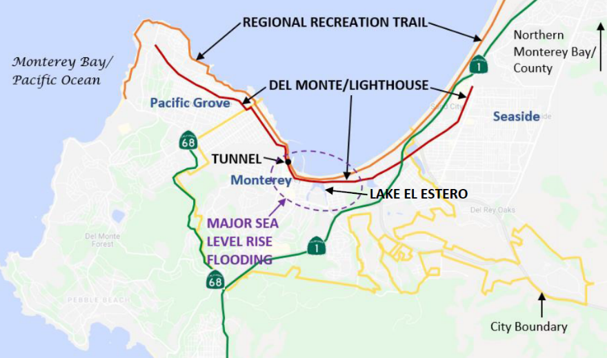
The City of Monterey serves over four million visitors each year and supports over 8,000 service jobs, making it the largest service industry center in Monterey County. Many of these employees travel from outside Monterey via car on Del Monte Avenue through the Lighthouse Tunnel or via bike on the adjacent Recreation Trail. In the event of extreme weather, the impact to both of these critical connections would be catastrophic. Flooding could significantly restrict emergency vehicle access and isolate areas of Monterey and adjacent cities from the rest of the peninsula. Ultimately, climate impacts to these critical transportation links could jeopardize the entire region's economic vitality and multi-modal connectivity.
This Study supports numerous state initiatives including the California Transportation Plan 2040, Safeguarding California Plan, the California Coastal Commission Sea Level Rise Policy Guidance, and the California Adaptation Planning Guide. The information gathered in this Study will feed into the City of Monterey General Plan Safety Element update to implement Senate Bill 379.
Lead Agency and Partnerships
The lead agency was the City of Monterey. The City held two local stakeholder meetings early in the process to discuss various sea level rise and flooding scenarios and identify potential impacts and their timing, which informed the types of adaptation strategies that would be explored. Local stakeholders included representatives from the U.S. Army Garrison Presidio of Monterey, Naval Support Activity Monterey, California Coastal Commission, Monterey-Salinas Transit, and Caltrans. Further collaboration with these and other entities such as the Transportation Agency for Monterey County, Association of Monterey Bay Area Governments, etc. will be necessary as the City moves into the next phase of choosing the best adaptation pathway. Coordination is necessary to synchronize with regional planning efforts addressing climate impacts and adaptation, including the 2040 Metropolitan Transportation Plan/Sustainable Communities Strategy and Regional Transportation Plan.
Drivers 
The project proposal is driven by the numerous aforementioned state initiatives as well as State Assembly Bill 691 and the 2040 Metropolitan Transportation Plan/Sustainable Communities Strategy and Regional Transportation Plan for Monterey County. The 2016 Report and several other local and regional sea level rise and erosion studies (see Additional Resources links) propelled the City of Monterey to advance its climate change adaptation efforts on the transportation system. The 2016 Report identified vulnerabilities, but did not provide tools, strategies or projects to address them. This Study provided transportation improvements and adaptation strategies to safeguard Monterey’s transportation network into the future. This Study was initiated and completed thanks to funding from the SB 1 Caltrans Adaptation Planning Grant Program.
Engagement Process
In addition to the two local stakeholder meetings, the City of Monterey held two virtual community workshops and invited all of its neighborhood and business associations; City boards, commissions, and committees; local stakeholders, such as Monterey-Salinas Transit, Transportation Agency for Monterey County, Caltrans, Army, Navy, Coastal Commission, and more. The workshop was advertised on the City’s website in English and Spanish, and a media release was sent to local media outlets. In addition, the City mailed a workshop postcard invitation in English and Spanish to every property in the Coastal Zone (600+ properties). Thirty-two people attended the first virtual workshop on May 13, 2020, including representatives from Fisherman’s Wharf Association, Naval Postgraduate School, Middlebury Institute of International Studies, New Monterey Neighborhood Association, Coastal Commission, City of Seaside, Caltrans, City of Pacific Grove, Monterey One Water, California State University Monterey Bay, Monterey Bay Aquarium, and Monterey Bay Air Resources District. The project consultants gave an overview of the project, sea level rise projections, consequences, and solutions. Then, workshop attendees asked questions and gave comments for about one hour. After that, participants were encouraged to take an online survey to choose their preferred transportation alternatives. Eighty-one people took the survey, with most preferring a managed retreat scenario with improved pedestrian and bicycle infrastructure. The consultants incorporated the survey results and preferred alternatives into a draft.
The draft, which included all previous work, conceptual plans, and preliminary cost estimates, was presented at the second virtual community workshop held by the Planning Commission at its regular meeting on December 8, 2020. The Planning Commission discussed the draft, provided input, and gathered community feedback, which shaped the final Study.
The project addressed the needs of disadvantaged communities by including transportation alternatives such as better pedestrian and bicycle facilities and public transit service. These communities are low-income with limited mobility and access options, such as commuters from affordable housing areas outside the City to service jobs in Monterey and people with second jobs.
Climate Impact Area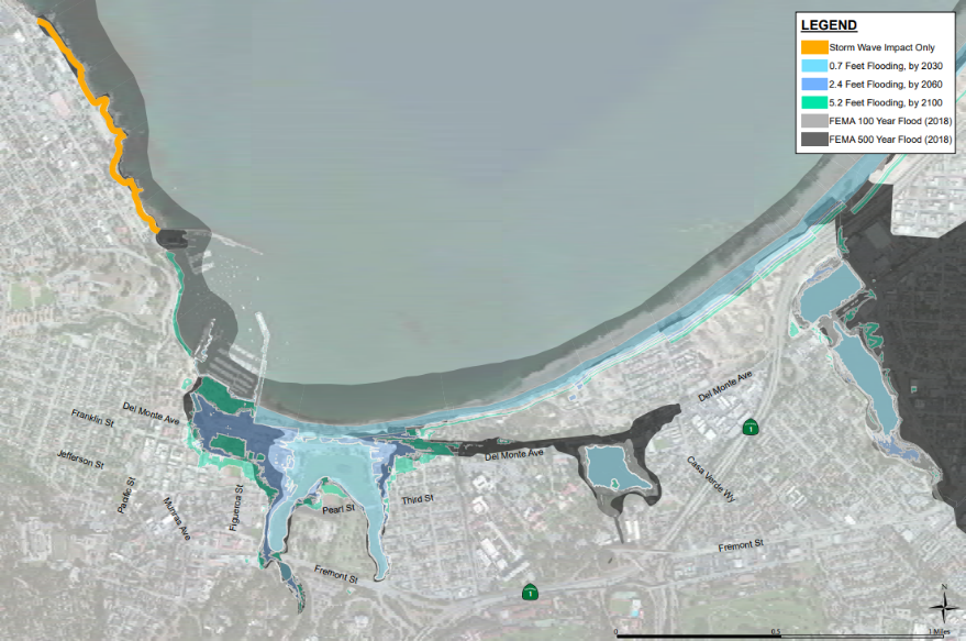
Several areas of vulnerability were identified in the 2016 Report and include two municipal wharves, local businesses, employment centers, schools and colleges, military facilities, archaeological sites, highly scenic areas, recreational sites, special neighborhoods which are significant visitor destination areas, and special marine and land habitat areas. Coastal flooding poses the largest vulnerability to public transportation, with Del Monte Avenue and Lighthouse Tunnel transit routes and the Recreation Trail being the most vulnerable. The Recreation Trail provides the only and best option for non-motorized travel connecting low-income commuters to service jobs, visitors to multiple attractions (Downtown/Cannery Row/Aquarium), residents to businesses, and students to schools.
Historically, large storms have flooded Del Monte Avenue and the Recreation Trail, causing disruption to bus routes and bike trails. The Lighthouse Tunnel is currently dewatered by a pump on a regular basis. The pump capacity will need to be addressed in light of the increase in volume of water to be pumped. The 2016 Report also found that by the year 2100 coastal flooding will impact approximately 20% of parking spaces in the City. However, the report did not provide tools, strategies or projects to address these vulnerabilities.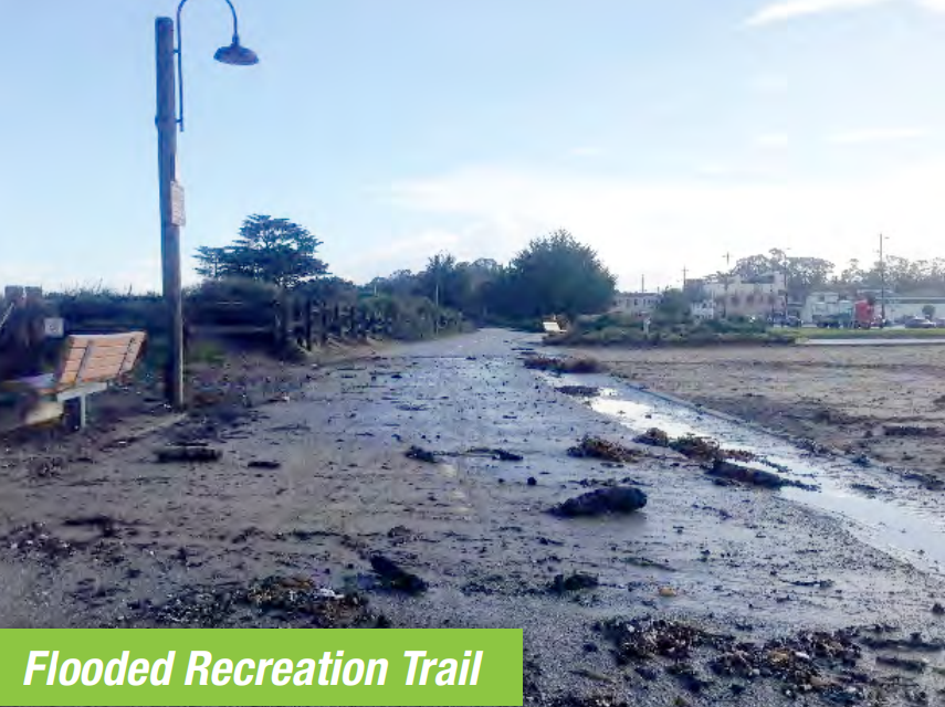
This Study created an inventory of adaptation options for the affected transportation network. However, the engagement process resulted in several preferred alternatives, and the project scope of work did not include a mechanism for choosing competing preferred alternatives. Conceptual designs and cost estimates were developed for these alternatives. The Study identified competitive grants as the primary source of funds for implementation of the adaptation strategies. The Study sparked a citywide conversation about the devastating impacts of sea level rise to our City. The topic is in the forefront of decision-makers’ minds when making policy and land use decisions. As mentioned earlier, this Study will feed into the City of Monterey General Plan Safety Element update to implement Senate Bill 379.
Funding Source
The City received $212,472.00 in SB1 Adaptation Planning Grant funds to complete the Study. The City provided a local match of $27,528.00, making the total project amount $240,000.00.
Research and Data
The Study used information identified in the Drivers section above. Existing vulnerabilities and general background data were collected from previous studies, including the 2016 Report and the AB 691 Report. These reports contained sea level rise and storm wave impact assumptions. Transportation modeling was informed by AMBAG’s Regional Travel Demand Model.
Challenges
The COVID-19 pandemic made public engagement more difficult. Our two virtual community workshops were originally planned as in-person workshops with free parking in order to accommodate people from all backgrounds. Due to the pandemic, the City moved the workshops to an online format. This made it difficult for disadvantaged communities with barriers to computer and internet access to attend. However, the City advertised the workshop in Spanish and provided a Spanish-English translator at all meetings.
It was also a challenge to identify the key adaptation options to evaluate and ensure that the needs and interests of diverse and sometimes competing goals were met. During the engagement process, there were two clear schools of thought with strong opinions about how to adapt to with sea level rise: build barriers such as sea walls or similar infrastructure to protect the City; or retreat from flood-prone areas, letting parts of the City flood, but do so in a managed, controlled manner with alternative transportation routes and other improvements. There are multiple landowners in the affected area, and their competing interests were and will continue to be an ongoing challenge to arrive at a preferred solution. As mentioned earlier, the project scope of work and budget did not include a mechanism for choosing between competing preferred alternatives. This was addressed by including both schools of thought into the final Study and comparing the pros, cons, and costs of each. Another challenge is that budget constraints limited the cost estimates to conceptual in nature. A robust benefit-cost analysis of each alternative will be needed to arrive at an adaptation pathway decision. This Study has provided baseline information from which more focused modeling efforts can be made. Funding, timing, and coordination are also going to pose challenges to implementing a solution.
Outcomes
The project identified two overarching alternatives for the impact area, summarized below.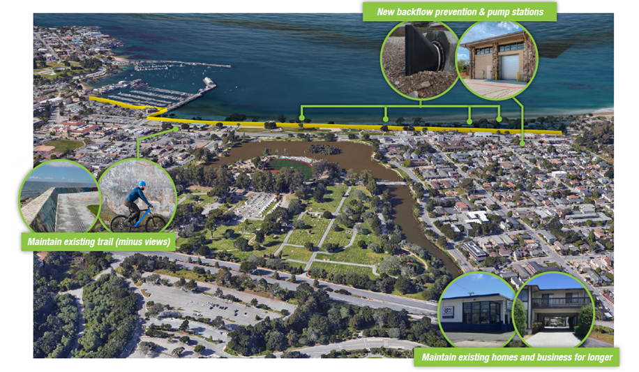
Under a Protect, or Flood Barrier, Plan, the City considered a variety of options to hold back rising seas for 4,536 linear feet of downtown Monterey. Three reaches (open parkland, a developed wharf, and a residential area) within this stretch of low-lying shoreline may each require different solutions. Two seawalls (a walkable sloped barrier adding 13’ elevation and a vertical concrete wall adding 17’ elevation) were costed. Additional options include levees, including an ecotone levee naturally landscaped with native plants, and various adjustments to the wharf shoreline. This project will help the City understand the additional costs and benefits of this option, including necessary alterations to drainage, and the potential long-term costs in low-lying areas from groundwater rise, altered corrosion rates of buried infrastructure, and social impacts from future flood insurance requirements.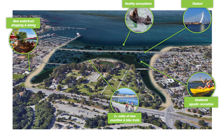
Under a Managed Retreat Plan, the City considered several options for rerouting critical transportation corridors around the current area, which would be gradually allowed to flood. Options include larger and smaller viaducts as well as converting collector and local roads to arterials and increasing mass transit and pedestrian opportunities. This project will help the City understand the additional costs and benefits of this option, including the costs of removal and relocation of critical infrastructure, the benefits of habitat restoration in Lake El Estero, and the economic tradeoffs of shifting existing residential and commercial land uses to a smaller area with potential enhanced coastal uses.
Anticipated next steps include a benefit-cost analysis and estimate for the full coastal infrastructure “protect” package, including maintenance and repair costs and considerations; a benefit-cost analysis and estimate for a full coastal infrastructure and built environment “retreat” package; a plan for the optimal location of beach nourishment/sand placement for Monterey beaches for both packages; a pre-feasibility memo for private property buyouts and mechanisms (supplemental to the “retreat” package); and engineering designs of each package. Together, these documents would form the basis for an ultimate City Council decision on which package to implement. However, multi-sector cooperation and planning will be key, and a City Council decision will be preceded by substantial coordination and outreach with regional and local partners as well as an extensive public engagement, education, and feedback solicitation process.
Replicability
All aspects of the project could be replicated for a community at risk of sea level rise impacts.
Additional Resources
The City of Monterey developed an online engagement platform for this project: https://haveyoursaymonterey.org/sea-level-rise-adaptation-plan. Most, if not all, previous related climate change studies can be found in this platform, including the final Study "Adapting a Threatened Transportation Network to Sea Level Rise".
Further Information
Please contact Fernanda Roveri, AICP, Interim Principal Planner at (831) 242-8788 or roveri@monterey.org.