Orange County Rail Infrastructure Defense Against Climate Change Plan
SB1 Adaptation Planning Grant: Final Case Study
Summary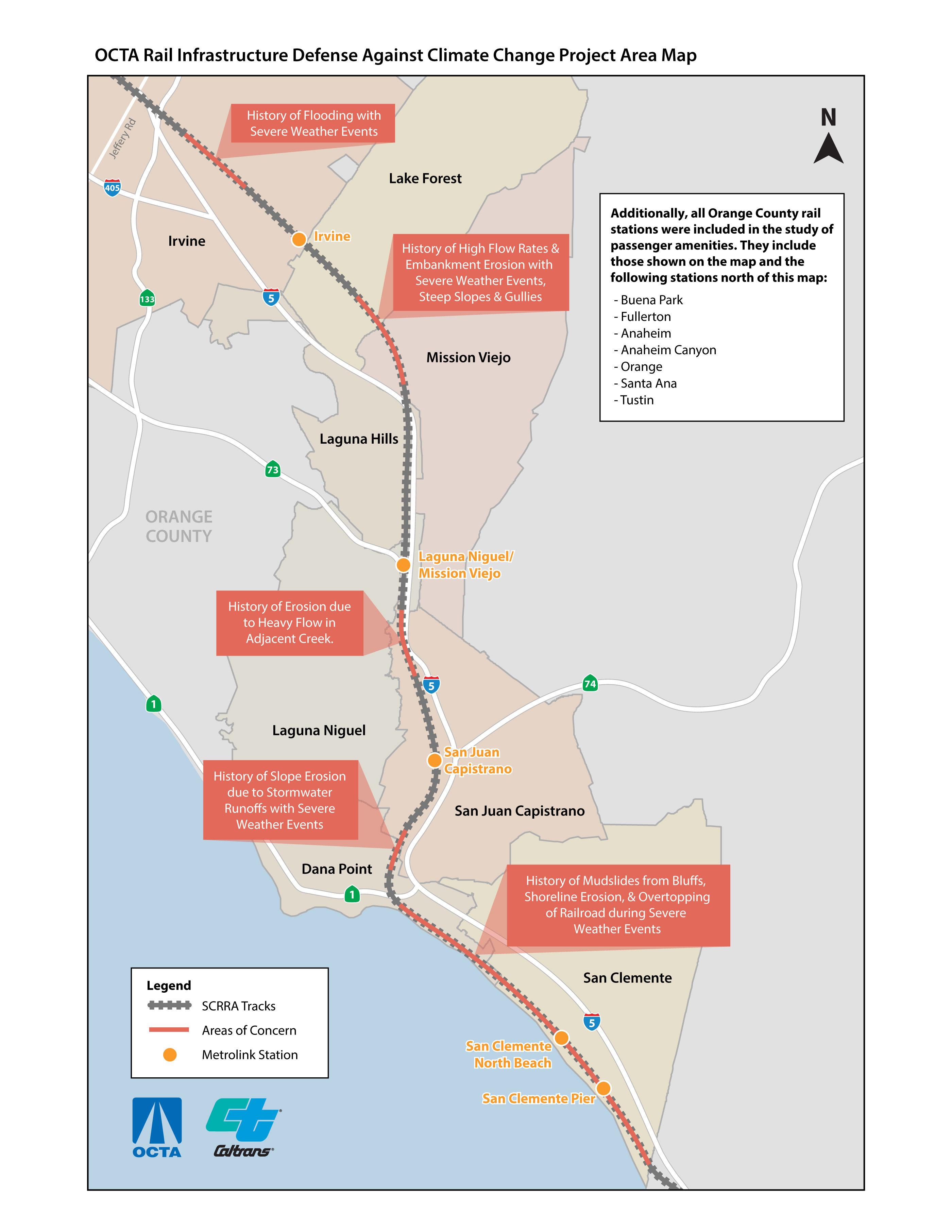
The Orange County Rail Infrastructure Defense Against Climate Change Plan (Plan) evaluated the exposure and risk levels of the rail corridor within Orange County Transportation Authority (OCTA)-owned rail right-of-way (ROW) south of the City of Irvine in Orange County and all Orange County rail stations against the negative outcomes of climate change stressors such as precipitation effects on erosion and flooding (coastal and inland), sea level rise and storm surge, high heat, wildfire and drought. The project study map is shown to the right. The project addressed the facility-level analyses aimed at estimating lifecycle costs of inaction and adaptation options as well as prioritizing these options for the rail system. The study identified specific climate hazard threats and offered mitigation solutions for segments of the railroad alignment and at stations as follows:
- Coastal alignment - erosion and flood risk and mitigations (MP 200.2 – 207.4)
- Inland alignment; Mission Viejo Trench and Extended Oso Creek Tributary (010)/Oso Creek - flooding and erosion/sediment control risk and mitigations (MP 189.0 – 194.6)
- Stations - passenger weather exposure and green infrastructure solutions
Facility-level assessments applied the Federal Highway Administration (FHWA) Adaptation Decision-Making Process (ADAP) as a framework to consider facility-level adaptation strategies and to develop recommended adaptation actions. The plan identified protective measures and climate change adaptation strategies which were tested against climate scenarios to evaluate the performance of the system with the implementation of adaptation options. An economic analysis which included life cycle costs assessments of the various adaptation options was performed to refine a Facility Adaptation Plan. The study can be used for future decision making and investments in transportation assets and services.
More than two thirds of the corridor is located in or near a Disadvantaged Community or Low-Income (DAC-LI) census tract, with approximately 270 DAC-LI census tracts within two miles of the corridor. In addition, of the 12 stations in Orange County, ten are in or near DAC-LI, providing service to these communities. Certain census tracts have up to 49 percent transit dependency. If the rail line were impacted, it would severely hinder transportation for these communities.
The 19-month long project started in September, 2019 and closed out in Spring 2021. The key project deliverables consist of field assessment matrices including inventory, parameters and deficiencies, and cost estimates, technical memoranda with summary and recommendations, and a final report. The final report will assist OCTA to plan, track and implement climate change related mitigations for the railroad corridor in south Orange County. Final deliverables can be viewed on the project webpage.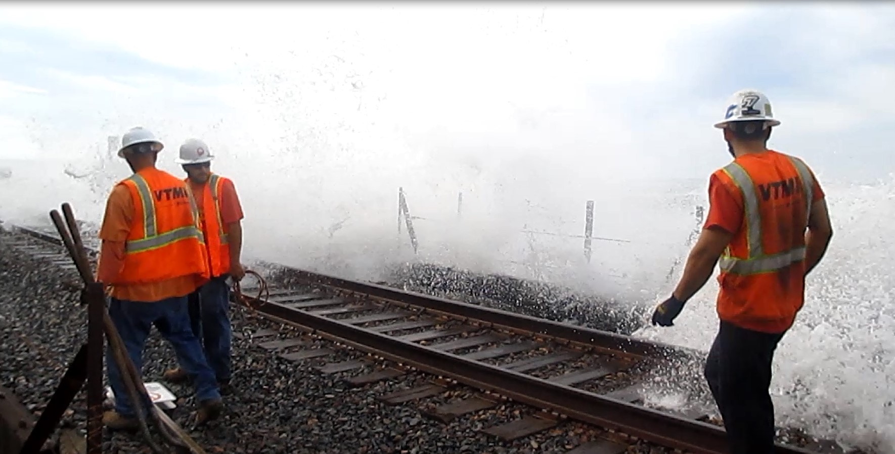
Lead Agency and Partnerships
OCTA as the lead agency on this project collaborated with key stakeholders Caltrans, Southern California Regional Rail Authority (SCRRA), and the Los Angeles – San Diego – San Luis Obispo (LOSSAN) Rail Corridor Agency) in the development of this project.
Caltrans as a key partner in the development of the initial scope of work and cost estimates, monitored project progress to ensure deliverables met project goals. SCRRA as the operator of the system and maintainer of the track, signals, structures, and most of the ROW provided maintenance records and safety protection for access to the railroad ROW during the facility assessment activities. The LOSSAN Corridor Agency operates the Amtrak Pacific Surfliner Intercity service that utilizes the rail corridor in this study.
Caltrans provided important project scope feedback and guidance for grant goals and requirements. Local Cities and agencies were also engaged to obtain necessary data and provide relevant input to the project. The County of Orange, California State Parks, Cities of Dana Point and City of San Clemente, the U.S. Army Corps of Engineers, and the California Coastal Commission were other important stakeholders in reviewing and providing input on coastal reaches of the railroad corridor.
Drivers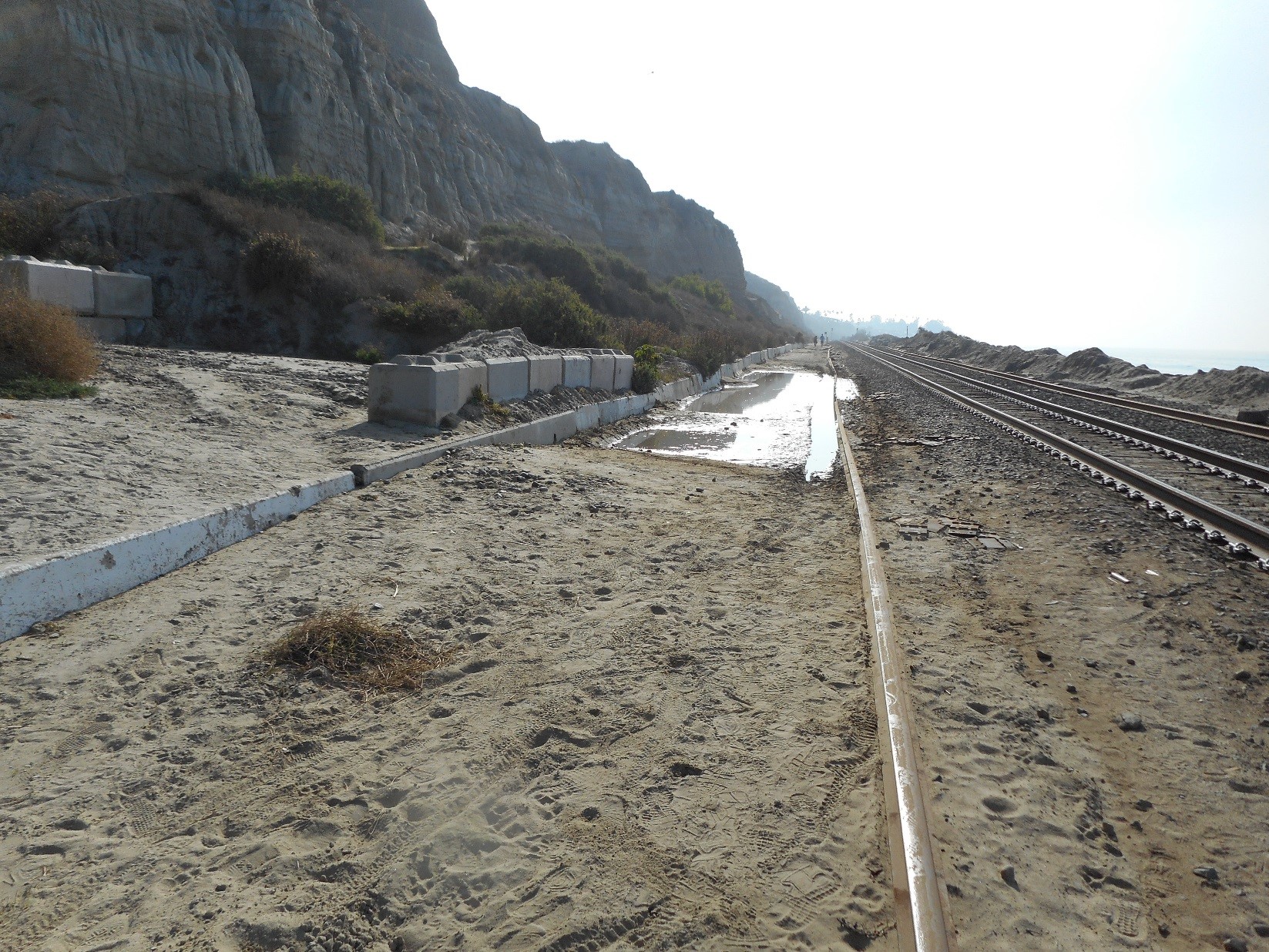
In December 2010, a rainstorm in the City of San Clemente caused mud slides that destroyed a section of the OCTA-owned Los Angeles-San Diego-San Luis Obispo (LOSSAN) rail corridor. The event disabled rail service between Orange County and San Diego, forcing rail users to use other modes of transportation in the congested Interstate 5 (I-5) corridor.
The Caltrans Adaptation Planning Grant Program offered OCTA the opportunity to identify potential climate change related issues on the OCTA-owned Orange subdivision in Orange County and develop solutions to improve and protect the rail corridor from impacts of climate change stressors such as storm activity, rising sea levels and wave action, and high heat.
Engagement Process
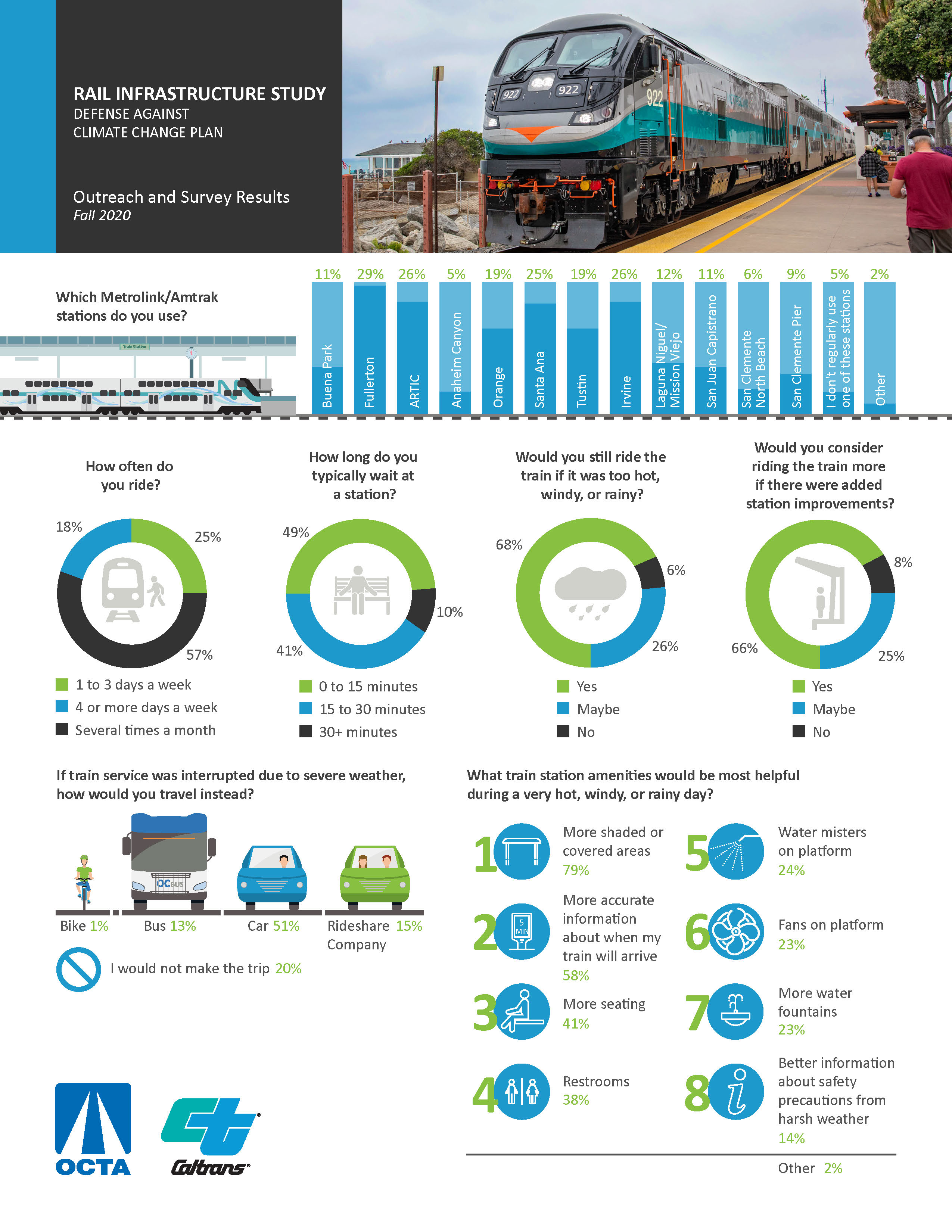
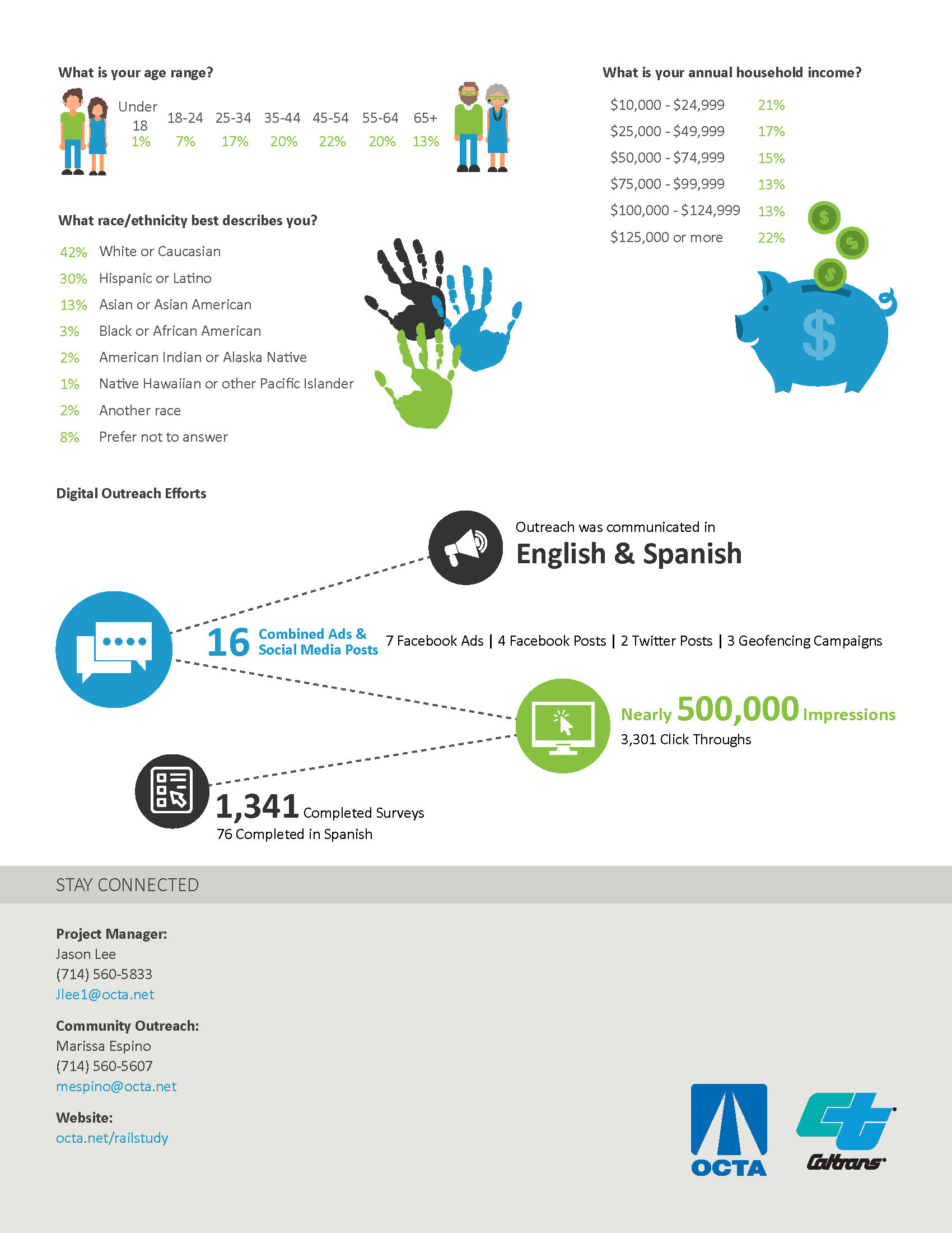
The Plan included a project development team comprised of OCTA, SCRRA, Caltrans, LOSSAN, and consultants to drive the progress of the project and its deliverables. Progress on the Plan and deliverables were communicated to a Project Working Group (PWG) which met over three workshops to discuss and provided input on project issues and study findings at specific decision points of the study to completion. The members of the PWG were solicited from a stakeholder list which included representatives from federal, state and local public entities. The public outreach component of the study conducted patron surveys on station amenities through social media channels and geofencing campaigns during the study period and provided valuable feedback on station amenity priorities. An infographic summarizing the outcomes of the public engagement process is shown at the bottom of the page.
Climate Impact Area
This project responds to storm activity, rising sea levels, temperature, and other climate change stressors.
The Plan conducted a comprehensive assessment of the southern rail corridor in Orange County and identified problematic locations, with near-term to long-term mitigation measures, and costs. The Plan determines mitigation measures that are most cost effective and beneficial to the region and corridor.
Funding Source
The total project cost was $659,641, with a $461,771 from a Caltrans Adaptation Planning Grant award, and $197,870 in local matching cash and in-kind support. The local match was 13% greater than originally budgeted.
Research and Data
See the final report bibliography for project references and data sources.
Challenges
Using the Right Science
The availability of relevant data to support analyses and an appropriate framework for the development of plans and strategies was uncertain during project scoping. This was quickly resolved during the data collection phase of the project as numerous sources of reliable information became available through consultant’s research and outreach to stakeholders. The FHWA ADAP framework also provided a suitable decision-making tool for the project.
Building Public Support
The project faced an unanticipated but significant challenge to its’ public outreach effort due to state government/local health official stay-at-home orders/movement restrictions resulting from the COVID-19 pandemic in 2020. The prolonged effects of the pandemic on transit ridership were also a concern that confronted the project team during the study period. Conventional in-person survey methods to capture public comments could not be implemented. The project team quickly adapted to this challenge by deploying patron surveys and through social media channels (Facebook and Twitter) and geofencing campaigns (location-based advertisement). These methods proved to be highly effective for collecting patron responses and capturing public input on station amenity improvements that would be most valuable to riders.
Developing Plans and Strategies
OCTA’s jurisdiction over limited railroad right of way within the County’s coastal corridor system presents challenges in the agency’s reach and ability to implement proposed plans and strategies; some of which may be in conflict with the interests of other stakeholders. Continued discussion and coordination with local, regional, and state agencies are necessary to reach climate change defense solutions that will benefit all stakeholders.
Outcomes
A final report including a summary of the findings of the study and recommendations was produced and will be used as a guiding document for planning, engineering and capital/maintenance investment decisions on the following aspects of the rail corridor and stations:
- Slope repair, reinforcement/revetment to reduce the risk for mudslides, flooding and coastal surge during storm events;
- Enhancement of vegetation management and sustainable vegetation strategy for periods of drought and high precipitation;
- Improve amenities at stations for passengers to enhance shade; and
- Long term adaptation measures such as rail relocation and cooperation with other agencies for beach nourishment efforts along the coastal segment of the railroad.
The project also conducted a benefit/cost analysis of the various adaptation options to address coastal alignment issues. The results are shown in Table 1.
The anticipated next steps for the coastal alignment is for OCTA to review performance criteria and utilize adaptation triggers based upon the best available projections and on the amount of time it takes to implement a solution. For the inland alignment and the stations, OCTA will evaluate and incorporate the recommendations as new projects are being developed within these locations.
Table 1. OCTA Benefit Cost Ratios (2% Discount Rate; Benefits are avoided Hazard-related Costs from Baseline; Costs are Installation costs)
Scenario |
Alternative |
Low End 80% Confidence Interval |
Best Guess |
High End 80% Confidence Interval |
|---|---|---|---|---|
|
Low (low emissions, 17% chance) |
Baseline Revetment |
- |
- |
- |
|
Low (low emissions, 17% chance) |
Improved Revetment |
4.09 |
4.88 |
5.56 |
|
Low (low emissions, 17% chance) |
Revetment w/ Seawall |
3.23 |
3.85 |
4.39 |
|
Low (low emissions, 17% chance) |
Relocation |
0.03 |
0.04 |
0.05 |
|
Medium (high emissions, 17% chance) |
Baseline Revetment |
- |
- |
- |
|
Medium (high emissions, 17% chance) |
Improved Revetment |
2.98 |
3.50 |
4.27 |
|
Medium (high emissions, 17% chance) |
Revetment w/ Seawall |
2.60 |
3.05 |
3.72 |
|
Medium (high emissions, 17% chance) |
Relocation |
0.03 |
0.04 |
0.05 |
|
High (high emissions, 0.5% chance) |
Baseline Revetment |
- |
- |
- |
|
High (high emissions, 0.5% chance) |
Improved Revetment |
2.21 |
2.60 |
2.86 |
|
High (high emissions, 0.5% chance) |
Revetment w/ Seawall |
2.29 |
2.69 |
2.96 |
|
High (high emissions, 0.5% chance) |
Relocation |
0.06 |
0.08 |
0.09 |
Replicability
Many aspects of this project are replicable to other communities or type of properties. This project is mainly focused on the railroad corridor and the stations. The project methodology and data sources can be applied to similar on transportation infrastructure management and protection against climate change.
Further Information
|
Louis Zhao Section Manager, Discretionary Funding Programs
Orange County Transportation Authority
(714) 560 - 5494
|
Jason Lee Project Manager, Rail Programs
Orange County Transportation Authority
(714) 560 - 5833
|
Additional Resources and Bibliography
Final study link: https://www.octa.net/programs-projects/programs/plans-and-studies/completed-studies/rail-infrastructure-study/
List of Project References:
- American Society of Civil Engineers. (2020). ASCE 7 Hazard Tool. Retrieved July 2020, from https://asce7hazardtool.online/
- Blickenstaff, K., Gangopadhyay, S., Ferguson, I., Condon, L., & Pruitt, T. (2013). Climate Change Analysis for the Santa Ana River Watershed. U.S. Department of the Interior Bureau of Reclamation. Retrieved from https://www.usbr.gov/lc/socal/basinstudies/OWOWReferences/FinalReport/TM%201%20Climate%20Change.pdf
- CA Environmental Protection Agency. (2011, November 3). WaterSense Specification for Weather-Based Irrigation Controllers Supporting Statement. Retrieved from http://www.epa.gov/sites/production/files/2017-01/documents/ws-products-support-statement-irrigation-controllers.pdf
- Cal Fire. (n.d.). Red Flag Warnings & Fire Weather Watches . Retrieved from ca.gov: https://www.fire.ca.gov/programs/communications/red-flag-warnings-fire-weather-watches
- California Coastal Commission. (2012). Staff Report, TH 11b. Retrieved from https://documents.coastal.ca.gov/reports/2012/7/Th11b-7-2012.pdf
- California Native Plant Society. (n.d.). Calscape - Restore Nature One Garden at a Time. Retrieved from http://www.calscape.org/
- California Natural Resources Agency and California Ocean Protection Council. (2018). Sea-Level Rise Guidance, 2018 Update.
- California Stormwater Quality Association. (2003). Bioretention. Retrieved from http://www.casqa.org/sites/default/files/BMPHandbooks/tc-32_from_newdevelopmentredevelopment_handbook.pdf
- California Water Boards. (n.d.). Appendix C - Cost Estimating Resources. Strategy to Optimize Resource Management of Stormwater.
- California Water Boards. (n.d.). Multi-Pollutant TMDL Implementation Plan for the Unicorporated County Area of Los Angeles River Watershed. Retrieved from http://www.waterboards.ca.gov/losangeles/board_decisions/basin_plan_amendments/technical_documents/2007-014/LA%20County%20Final%20LA%20MetalsTMDL%20IP_Appendices.pdf
- Caltrans, Hydraulics and Stormwater. (n.d.). Pervious Pavement Design Guidance. Retrieved from https://www.uni-groupusa.org/PDF/Caltrans%20DG-Pervious-Pvm_102913.pdf
- CDC. (2017, June 19). Tips for Preventing Heat-Related Illness. Retrieved from Centers for Disease Control and Prevention: https://www.cdc.gov/disasters/extremeheat/heattips.html
- Center for Climate and Energy Solutions. (2017). Resilience Strategies for Extreme Heat. Retrieved from https://www.c2es.org/site/assets/uploads/2017/11/resilience-strategies-for-extreme-heat.pdf
- City of Anaheim. (2016). Anaheim Canyon Specific Plan. City of Anaheim. Retrieved from http://www.anaheim.net/DocumentCenter/View/9965/Chapter-5---Implementation?bidId=
- County of Los Angeles Department of Public Works. (2010). Stormwater Best Management Practice Design and Maintenance Manual.
- Dealing with Extreme Heat RIsks: A Narrative on Promising Practices for Local Governments and Their Citizens. (n.d.). Retrieved from https://climas.arizona.edu/sites/default/files/pdfextreme-heat-toolkit-narrative.pdf
- Delgado, M., Ramos, J., Dominguez, S., Ulloa, F., & Rios, J. (2020). Evaporative mist cooling as heat dissipation technique: experimental assessment and modelling. Applied Sciences, 10(6026). doi:10.3390/app10176026
- Diehl, P. (2019, July 28). Del Mar is weak link in San Diego's coastal railroad. Del Mar Times. Retrieved from https://www.delmartimes.net/news/story/2019-07-28/del-mar-is-weak-link-in-san-diegos-coastal-railroad
- Environmental Protection Agency. (n.d.). Reducing Urban Heat Islands: Compendium of Strategies
- Environmental Protection Agency, Office of Wetlands, Oceans, and Watersheds. (2015). Green Infrastructure Opportunities that Arise During Municipal Operations.
- Erikson, L., Barnard, P., O'Neill, A., Vitousek, S., Limber, P., Foxgrover, A., . . . Warrick, J. (2017). Coatal Storm Modeling System (CoSMoS) for Southern Califorina, v3.0, Phase 2. doi: http://dx.doi.org/10.5066/F7T151Q4
- Evan, M. (n.d.). Watering Native Plants. Tree of Life Nursery, California Native Plants. Retrieved from http://www.californianativeplants.com/PDFs/Watering-Native-Plants.pdf
- Farnham, C., Emura, K., & Mizuno, T. (2015). Evaluation of cooling effects: outdoor water mist fan. Building Research & Information, 45(7), 783-799. doi:10.1080/09613218.2017.1278651
- Farnham, C., Zhang, L., Yuan, J., Kazuo, E., Alam, A. M., & Mizuno, T. (2017). Measurement of the evaporative cooling effect: oscillating misting fan. Building Research & Information, 45(7), 783-799. doi:10.1080/09613218.2017.1278651
- Federal Emergency Management Agency. (2015). Guidance for Flood Risk Analysis and Mapping - Calculation of Incident Wave Height and Slope for use with TAW Wave Runup Method. U.S. Department of Homeland Security.
- Federal Emergency Management Agency. (2015). Guidance for Flood Risk Analysis and Mapping - Coastal Wave Setup. U.S. Department of Homeland Security.
- Federal Emergency Management Agency. (2018). Guidance for Flood Risk Analysis and Mapping - Coastal Wave Runup and Overtopping. FEMA.
- Federal Emergency Management Agency. (2019). Flood Insurance Study, Orange Co. California and Incorporated Areas, Flood Insurance Study No. 06059CV001C. U.S. Department of Homeland Security.
- Federal Highway Administration. (1993). Design of Bridge Deck Drainage (HEC 21). Retrieved from Bridges & Structures: https://www.fhwa.dot.gov/engineering/hydraulics/library_arc.cfm?pub_number=21&id=46
- Federal Highway Administration. (2012). Evaluating Scour at Bridges (Fifth Edition, Hydraulic Engineering Circular No. 18). Retrieved from Bridges & Structures: https://www.fhwa.dot.gov/engineering/hydraulics/library_arc.cfm?pub_number=17&id=151
- Federal Highway Administration. (2012, 10 1). Hydraulic Design of Energy Dissipators for Culverts and Channels (Hydraulic Engineering Circular No. 14, Third Edition). Retrieved from Bridges & Structures https://www.fhwa.dot.gov/engineering/hydraulics/library_arc.cfm?pub_number=13&id=129
- Federal Highway Administration, Office of Planning, Environment, and Realty. (2019). Adaptation Decision-Making Assessment Process (ADAP) . Retrieved from FHWA : https://www.fhwa.dot.gov/environment/sustainability/resilience/ongoing_and_current_research/teacr/adap/index.cfm
- Flick, R. (2016). California tides, sea level, and waves. Shore & Beach, 84(2).
- Houdeshel, C., & Pomeroy, C. (2010). Plant Selection for Bioretention in the Arid West. In Low Impact Development 2010: Redefining Water in the City (pp. 1475-1485).
- Irvine Ranch Water District. (n.d.). GIS Maps and Records . Retrieved from https://www.irwd.com/doing-business/gis-map-and-records/
- Khuu, J. (2007). A Loophole to Repair: "Repair and Maintenance" as a Way around the Coastal Act's Prohibition Against Seawalls. Hastings Law Journal, 1297-1330.
- Lovett, A. H., Dick, T. C., & Barkan, C. P. (2015). Determining Freight Train Delay Costs on Railroad Lines in North America. Urbana, IL: Rail Transportation and Engineering Center (RailTEC), Department of Civil Engineering, University of Illinois at Urbana-Champaign. Retrieved from https://railtec.illinois.edu/wp/wp-content/uploads/2019/01/Lovett-et-al-2015-IAROR.pdf
- Lund, J., Medellin-Azuara, J., Durand, J., & Stone, K. (2018, October). Lessons from California's 2012-2016 Drought. Journal of Water Resources Planning and Management, 144(10). Retrieved from https://ascelibrary.org/doi/full/10.1061/%28ASCE%29WR.1943-5452.0000984
- Metrolink. (2016). Restoration of Rip Rap on the Orange Subdivision over the Weekend of March 5th and 6th .
- Middel, A., Selover, N., Hagen, B., & Chhetri, N. (2016). Impact of shade on outdoor thermal comfort - a seasonal field study in Tempe, Arizona. International Journal of Biometeorology. Retrieved from https://doi.org/10.1007/s00484-016-1172-5
- Mohammad, T. (2019). Outdoor thermal comfort by different heat mitigation strategies - A review. Renewable and Sustainable Energy Reviews. Retrieved from https://doi.org/10.1016/j.rser.2017.06.010
- Mulkern, A. C. (2020, July 13). Blackouts Have Triggered an Energy Storage Boom in California. E&E News, Energy. Retrieved from https://www.scientificamerican.com/article/blackouts-have-triggered-an-energy-storage-boom-in-california/
- National Association of City Transportation Officials. (2017). Inlet Design. Retrieved from http://www.nacto.org/publication/urban-street-stormwater-guide/stormwater-elements/bioretention-design-considerations/inlet-design/
- National Oceanographic and Atmospheric Administration. (2020). Center for Operational Oceanographic Products and Services, Tides and Currents. Retrieved April 2020, from https://tidesandcurrents.noaa.gov/
- OSHA. (n.d.). Water. Rest. Shade. Keeping Workers Safe in the Heat. Retrieved from US Department of Labor: Occupational Safety and Heath Administration: https://www.osha.gov/heat/index.html
- Our Coast Our Future. (2019). Data Access Viewer for CosMos Modeling Results. Retrieved May 2019, from http://data.pointblue.org/apps/ocof/cms/
- Plants, N. (n.d.). Plant Adaptation Habits. Retrieved from http://www.nativeplants.org/wp-content/uploads/Plant-Adaptations-Tour.pdf
- Rainbird. (n.d.). LEED and Rain Bird Water Efficient Products. Retrieved from https://www.rainbird.com/sites/default/files/media/documents/2018-06/LEED_Products_WaterEfficient_2018.pdf
- Rector, P., Brown, J., & Obropta, C. (n.d.). Green Infrastructure Practices: Tree Boxes. Rutgers, New Jersey Agricultural Experiment Station. Retrieved from https://njaes.rutgers.edu/fs1209/
- San Diego Association of Governments. (2020, June 5). Comprehensive Multimodal Corridor Plans [slides for Transportation Committee Item 6 on June 5, 2020]. Retrieved from https://www.sandag.org/uploads/meetingid/meetingid_5299_27523.pdf
- San Diego County Water Authority. (n.d.). Create a Budget for Landscape Retrofits. Retrieved from https://www.dscwa.org/sites/default/files/budget_landscape_retrofits_fs.pdf
- Save Our Water. (2019, March 14). Using California Native Plants. Retrieved from Save Our Water: https://saveourwater.com/using-california-native-plants/
- State of California. (2019). California's Fourth Climate Change Assessment: Los Angeles Region Report. Retrieved from https://www.energy.ca.gov/sites/default/files/2019-11/Reg%20Report-%20SUM-CCCA4-2018-007%20LosAngeles_ADA.pdf
- State of California. (n.d.). Chapter 3: California Coastal Act. Retrieved from https://www.coastal.ca.gov/fedcd/cach3.pdf
- State of California, CalEPA. (n.d.). Urban Heat Island Interactive Maps. Retrieved from http://www.calepa.ca.gov/climate/urban-heat-island-index-for-california/urban-heat-island-interactive-maps/
- State of California, Department of Transportation. (2004). LOSSAN, Los Angeles to San Diego Proposed Rail Corridor Improvements in the State of California, Draft Program Environmental Impact Report/Statement. Retrieved from https://books.google.com/books?id=57E2AQAAMAAJ&pg=RA16-SA12-PA22&lpg=RA16-SA12-PA22&dq=caltrans+environmental+impact+statements+district+12+Lossan&source=bl&ots=46wOhrwuj3&sig=ACfU3U2NCgK1ecnFCXVk_2FQFTBMSkwNMg&hl=en&sa=X&ved=2ahUKEwiCuKyqzenpAhWul3IEHa2Y
- Sumer, B., & Fredsoe, J. (2002). The Mechanics of Scour in the Marine Environment. World Scientific Publishing Co., Pte. Ltd.
- Taleghani, M. (2018). Outdoor thermal comfort by different heat mitigation strategies - A review. Renewable Sustainable Energy Review. doi: https://doi.org/10.1016/j.rser.2017.06.010
- Taleghani, M., Crank, P., Mohegh, A., Sailor, D., & Ban-Weiss, G. (2019). The impact of heat mitigation strategies on the energy balance of a neighborhood in Los Angeles. Solar Energy(177). Retrieved from 10.1016/j.solener.2018.11.041
- U.S. Army Corps of Engineers . (2002). Coatal Engineering Manual (CEM), Engineer Manual 1110-2-1100. Washington, D.C. : USACE.
- U.S. Army Corps of Engineers. (2020, April). Wave Information Studies. Retrieved from USACE : http://wis.usace.army.mil/hindcasts.html?dmn=pacific
- Ulpiani, G. (2019). Water mist spray for outdoor cooling: A systematic review of technologies, methods and impacts. Applied Energy, 254(113647). doi:10.1016/j.apenergy.2019.113647
- United States Geological Survey. (2016). 2016 USGS Coastal National Elevation Database (CoNED) Topobathymetric Model (1930 - 2014) for the Southern Coast of California and Channel Islands. Retrieved from National Oceanographic and Atmospheric Administration Data Access Viewer: https://coast.noaa.gov/htdata/raster2/elevation/CA_Southern_CoNED_DEM_2016_8658/
- University of Arizona. (n.d.). Dealing with Extreme Heat Risks: A Narrative on Promising Practices for Local Governments and Their Citizens. Retrieved from https://climas.arizona.edu/sites/default/files/pdfextreme-heat-toolkit-narrative.pdf
- University of California, Division of Agriculture and Natural Resources. (n.d.). Questions and Answers About Drought & Water Conservation. Retrieved from Center for Landscape and Urban Horticulture.
- University of California, Division of Agriculture and Natural Resources, Center for Landscape and Natural Resources. (n.d.). Landscape Water Requirements Calculators. Retrieved from https://ucanr.edu/sites/UrbanHort/Water_Use_of_Turfgrass_and_Landscape_Plant_Materials/Water_Demand_Calculators/Water_Demand_Calculators/index.cfm
- US Department of Agriculture. (n.d.). Conservation Stewardship Program. Retrieved from www.nrcs.usda.gov/wps/portal/nrcs/detail/national/programs/financial/?cid=nrcseprd1328227
- US DOE, Office of Energy Efficiency and Renewable Energy. (2019). Energy Efficiency and Distributed Generation for Resilience: Withstanding Grid Outages for Less. Retrieved from https://www.energy.gov/sites/prod/files/2019/06/f64/EEDG-Resilience.PDF
- US Environmental Protection Agency. (1999). Stormwater technology fact sheet--bioretention. Retrieved from https://nacto.org/wp-content/uploads/2012/06/US-EPA-1999.pdf
- US EPA. (2018, September 12). Cool Fixes for Hot Cities Part 2: Los Angeles . Retrieved from epa.gov: https://www.epa.gov/sites/production/files/2018-09/documents/heat-island-webcast-cool-fixes-part-2-2018-09-12_0.pdf
- US Forest Service . (n.d.). Fire in Chaparral Ecosystems. Retrieved from US Forest Service, Pacific Southwest Research Station: https://www.fs.fed.us/psw/topics/fire_science/ecosystems/chaparral.shtml
- USACE. (2012). The Final Report for the San Clemente Shoreline Feasibility Study . Washington D.C.: U.S. Government Printing Office.
- Van Der Meer, J., Allsop, N.W.H. , Bruce, T., De Rouck, J., Kortenhaus, A., Pullen, T., . . . Zanuttigh, B. (2018). EurOtop. Retrieved April 2020, from http://www.overtopping-manual.com/
- Vanaskie, M., Myers, R., & Smullen, J. (2010). Planning-level cost estimates for green stormwater infrastructure in urban watersheds. Low Impact Development 2010: Redefining Water in the City, 547-558.
- Vickers, A. L. (1999). Handbook of water use and conservation.
- Weather Spark. (n.d.). Retrieved from https://weatherspark.com/
- Westropp, M., & Woodside, G. (2015). Orange County Water District Groundwater Management Plan 2015 Update. Orange County Water District. Retrieved from https://www.ocwd.com/media/3503/groundwatermanagementplan2015update_20150624.pdf
- Whole Building Design Guide . (n.d.). Permeable Pavement . Retrieved from https://www.wbdg.org/FFC/ARMYCOE/TECHNOTE/technote11.pdf
- Widerynski, S., Schramm, P., Conlon, K., Noe, R., Grossman, E., Hawkins, M., . . . Hilts, A. (n.d.). The use of cooling centers to prevent heat-related illness. Center for Disease Control. Retrieved from https://www.cdc.gov/climateandhealth/docs/UseOfCoolingCenters.pdf