Central Coast Highway 1 Climate Resiliency Study
SB1 Adaptation Planning Grant: Final Case Study
Brief Summary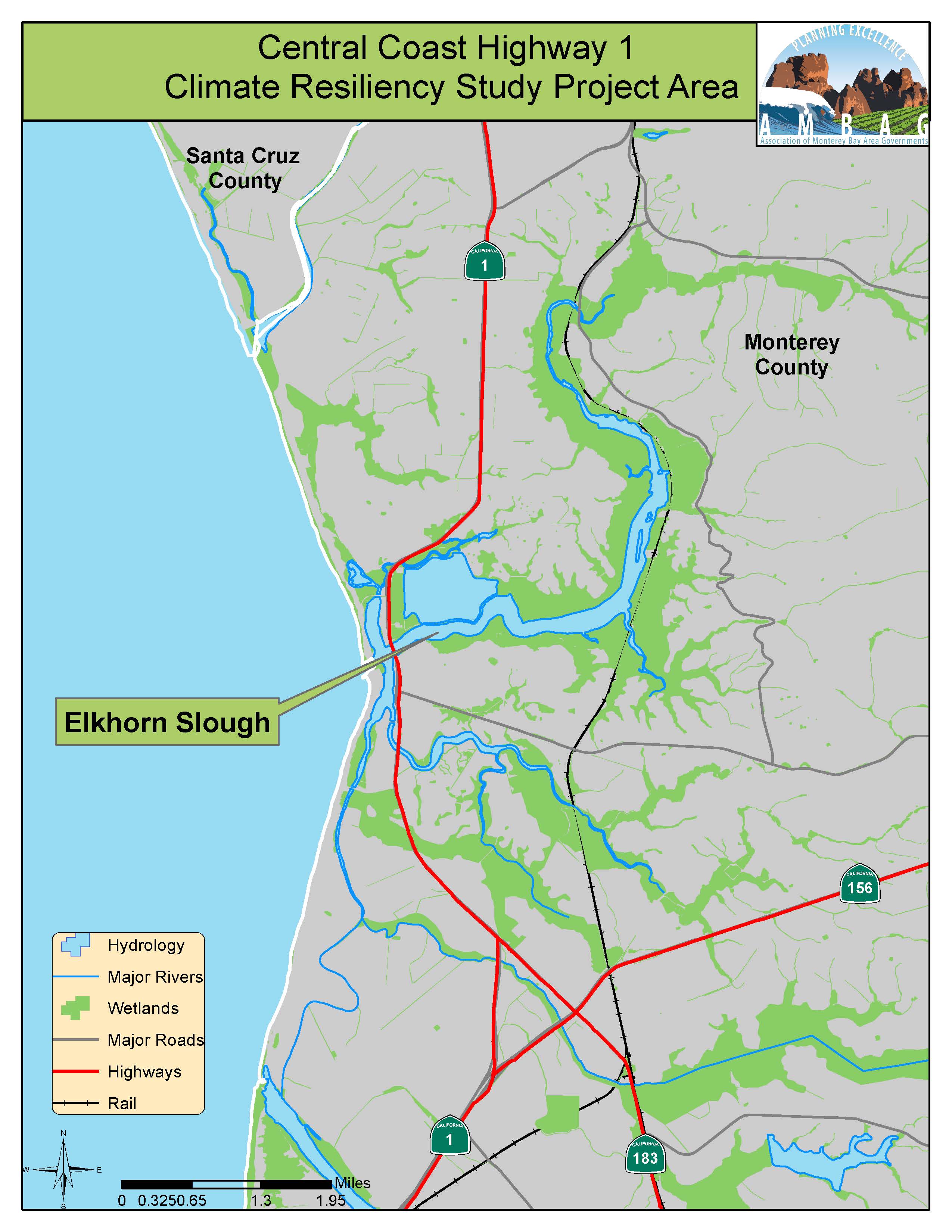
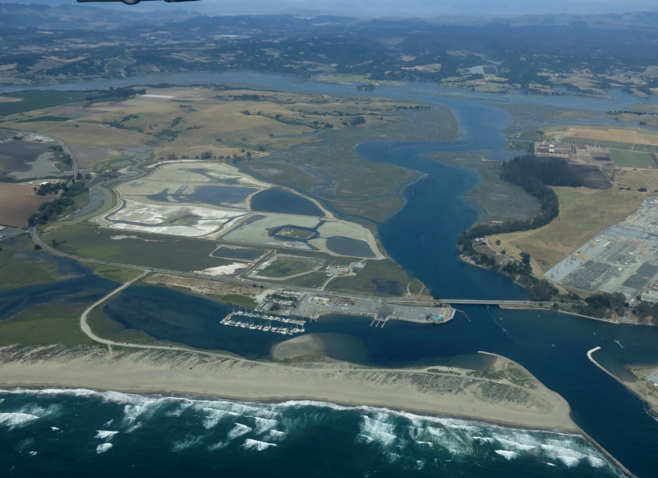
The eight-mile stretch of Highway 1 near Elkhorn Slough is already constrained and will be increasingly impacted by coastal storm flooding and sea level rise. Driven by a need to sustain this critical transportation corridor and protect the iconic coastal habitat in the face of the challenges posed by climate change, a suite of partners in the Monterey Bay area are working together to find innovative ways to address this complex transportation adaptation problem. The study aimed to explore creative transportation solutions and the use of natural infrastructure approaches to promote transportation, habitat, and economic resilience for the region.
The Association of Monterey Bay Area Governments (AMBAG), in conjunction with The Nature Conservancy (TNC) and the Center for Blue Economy (CBE), prepared a climate resiliency study for the Central Coast Highway 1 corridor from State Route 156 near Castroville to Salinas Road near the Monterey/Santa Cruz county line. This study provides a conceptual climate change adaptation transportation planning foundation for integration into the AMBAG Metropolitan Transportation Plan/Sustainable Communities Strategy (MTP/SCS). This effort identified transportation improvements and sea level rise adaptation strategies for Highway 1 that can improve transportation mobility, safety and efficiency, promote healthy habitats, and provide economic security and benefits to the local community. The goal of this collaborative approach was for the completed plan to lead to implementation and development of adaptation projects, by being incorporated into local and regional plans.
This two year study kicked-off in spring 2018.
Lead Agency and Partnerships
AMBAG was the study lead, in partnership with The Nature Conservancy (TNC) and Center for the Blue Economy (CBE). In addition to the leads for the study, there was steering committee involvement. More information on the steering committee can be found in the “Engagement Process” section of this report.
Drivers
This study aimed to help local governments in the AMBAG Region in addressing climate change. The study supports State initiatives and priorities including EO-S-13-08, which directs state agencies to plan for sea level rise and climate impacts. This study allowed the region to prepare for sea level rise and climate change impacts to Highway 1 within the study area and the results had translatable findings along the coastal highway. Per Senate Bill 379 (SB 379), local governments must address climate change adaptation and resiliency in their general plans. This study provides information that can be included in General Plan updates to address coastal resiliency along the Monterey Bay coastline. In furtherance of the intention of the ICARP Program, this analysis linked regional climate vulnerabilities with adaptation guidance from the state level. This study would not be possible without the funding made available through the SB 1 Adaptation Planning and Caltrans Sustainable Planning grant funds.
Engagement Process
Through the development of the plan, the study identified vulnerable populations through the involvement of local stakeholders and the Steering Committee.
The study’s Steering Committee was comprised of representatives from the relevant transportation agencies (Caltrans at both Headquarters and in District 5, AMBAG, and TAMC), as well as the relevant coastal management agencies (the California Coastal Commission, the California State Coastal Conservancy, Monterey County’s Resource Management Agency, and the Elkhorn Slough National Estuarine Research Reserve), local non-profits specializing in coastal resilience and restoration, and an academic institution (The Center for a Blue Economy).
The study demonstrated an on-going collaboration and long-term partnership between sectors and jurisdictions, and across levels of government at a regional scale. The study worked closely with diverse external stakeholders and members of the public incorporating their considerations into the process for identifying adaptation approaches and selecting which were the best to consider for this stretch of coastal highway and habitat. Two community workshops were held, as well as other stakeholder meetings and presentations, with public and stakeholder comments being incorporated into the final plan.
Climate Impact Area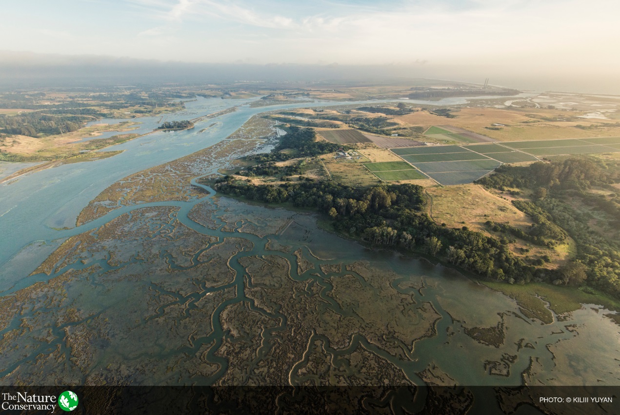
Transportation infrastructure is prone to flooding and vulnerable to sea level rise, and is adjacent to valuable wetland habitats of Elkhorn Slough National Estuary. Much of these valued habitats are also vulnerable to sea level rise. We have an opportunity to increase the resilience of transportation infrastructure and habitat to sea level rise and climate change. This effort creates a new model for transportation planning that increases the resilience of transportation infrastructure by proactively addressing climate change impacts while simultaneously addressing existing issues, such as reducing flooding risk, greenhouse gas emission, etc.
Funding Source
SB 1 Adaption Planning Grant: $360,000
Caltrans Sustainable Communities Planning Grant: $75,000
Local Cash/In Kind Match: $78,502
Total: $513,50
Research and Data
Data was collected on existing vulnerabilities and general background information on the study area. As part of the general existing data collection effort for this study, ESA collected field survey data for culverts located beneath Highway 1 in the study area and existing hydraulic structure datasets from local technical groups. Culvert and hydraulic structure information were used to inform the DELFT-3D hydrodynamic modeling performed as part of this study. Sea-level rise assumptions were adapted from the California Ocean Protection Council (OPC). Transportation modeling was informed by AMBAG’s Regional Travel Demand Model. A full list of data sources can be found in the study report.
Challenges
The major challenges were identifying the key adaptation options to evaluate and ensuring that the needs and interests of diverse and sometimes competing goals were met. As this is a unique study that combines transportation adaptation alongside ecological adaptation, coordinating the modeling results and translating this into the best combination of adaptation scenarios presented challenges. These were addressed by frequent collaboration within the Project Team, Steering Committee meetings, public workshops and one-on-one meetings to address their concerns.
Funding, timing and coordination are going to be the biggest challenges for implementing this study.
Outcomes
This study developed a framework for addressing climate change vulnerabilities along the Highway 1 corridor. This evaluation framework integrated consideration of the values of natural resources with corridor transportation needs, as well as considered a sustainable transportation corridor that supports a growing population, a vibrant economy, and preserves sensitive coastal habitat.
The study aimed to:
- Overcome the shortcomings of traditional corridor studies by developing an analytical approach that merges consideration of the values of natural resources with transportation mobility and efficiency priorities; and
- Develop a decision support process to identify the best adaptation pathway (timing and approach) that reflects an understanding of risks over time as well as consequential negative ancillary impacts to the environment and economy.
The economic analysis consists of two phases: (a) an economic cost benefit and impact analysis, and (b) an assessment of risks to determine the appropriate timing of sequential adaptation actions. The two elements combined to design the most cost effective adaptation pathway.
Knowing that there are multiple options for adaptation, some of which are cost-superior and some of which are much closer in cost and benefits depending on assumptions, is useful, but still does not facilitate immediate decision-making on critical vulnerabilities. The project team developed an evaluation framework to facilitate that decision-making and prioritization process.
The dual nature of the study necessitates the use of several models to establish the performance of the adaptation scenarios with respect to transportation and ecological parameters. Flood hazard modeling for existing and future sea levels was conducted using Coastal Resilience methods, with refinements for existing and future conditions. Hydrodynamic modeling and habitat evolution modeling were conducted for the adaptation scenarios in order to establish impacts to wetland habitats. Transportation modeling was conducted to assess future transportation function as a result of adaptation and improvements. Outputs from these modeling processes informed the economic benefit cost analysis portion of the scenarios evaluation.
A suite of near-term actions (e.g. next 10 years) were identified to mitigate flooding impacts to transportation and ecology, in addition to developing long-range adaptation scenarios that could be implemented. The adaptation pathways approach yields deeper insight into what additional steps (e.g. planning, timing, funding) may be necessary to bridge near-term actions to a long-term vision. After assessing a preliminary suite of adaptation scenarios, three revised roadway and railway adaptation scenarios, which were compared against a no action scenario, were evaluated. The roadway and railway adaptation scenarios were evaluated using best available locally specific data to inform a series of modeling tools investigating systemic changes to hydrology, transportation, and ecology triggered by sea level rise and adaptation actions. Given the complex nature of climate related impacts to the transportation, ecological and community resources, the study does not suggest a single preferred adaptation scenario for further evaluation.
While not an exhaustive list, a number of key takeaways and 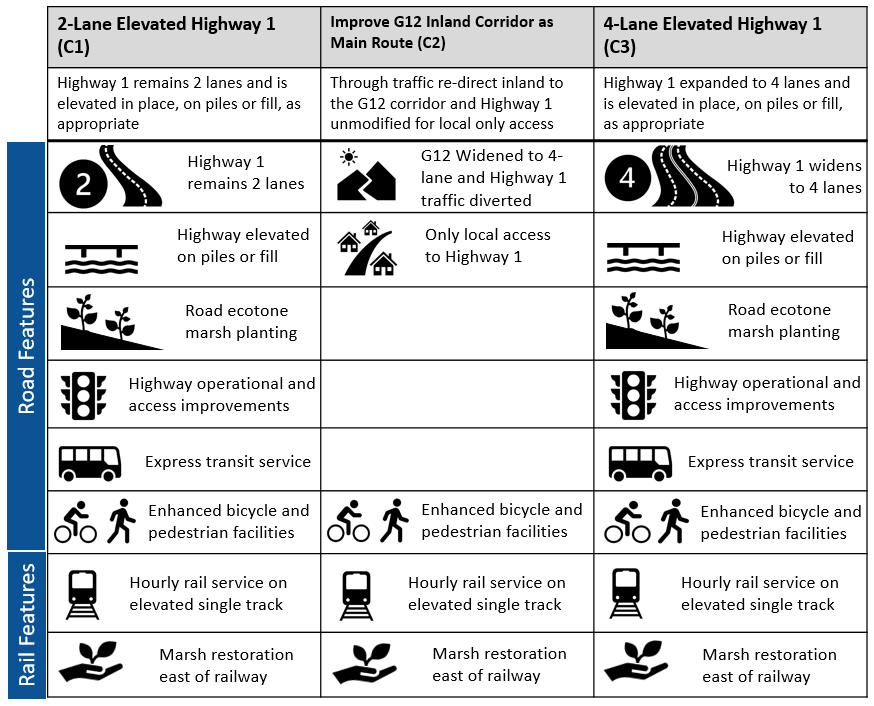 considerations for future planning were drawn from the study process, approach, methodologies and results from the analyses:
- Choosing not to adapt to sea level rise will result in widespread loss of coastal habitat, significant transportation impacts and economic losses
- Adaptation of the highway with nature-based elements help to reduce the loss of marsh habitat
- Adaptation needs to be in place by 2050 to ensure benefits to transportation and habitats
- Multi-sector cooperation and planning is key
- Planning for ecosystem migration is critical to increase future habitat and overall resilience of Elkhorn Slough.
Replicability
A new evaluation framework was established through this study. This new framework will pave the way for holistic corridor management in the face of climate change, not only for the Monterey Bay area, but across the California coast in other places where environmental and infrastructure vulnerability coincide.
Additional Resources
Information on AMBAG’s Regional Travel Demand Model
Further Information
For additional information, please contact Heather Adamson: (831) 264-5086; hadamson@ambag.org