Urban Cooling Strategies for Los Angeles Neighborhoods Serviced by the Orange Line
SB1 Adaptation Planning Grant: Final Case Study
Brief Summary
Extreme heat kills more Americans every year than any other weather-related 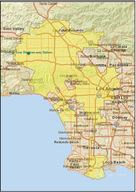 disaster. Scientists predict that within the next 20-30 years, the average temperature in Los Angeles will rise by 4-5°F, and the occurrence of extreme heat days (which is when temperatures exceed 95 °F) will dramatically increase in vulnerable neighborhoods like Canoga Park in Los Angeles to up to 92 days per year.
This project focused on a study area within a 10-minute walk (half-mile) from the Sherman Way Station Orange Line Metro Station in Canoga Park, exploring conceptual designs to simultaneously mitigate extreme heat (“Urban Cooling”) and improve transit access (“First/Last Mile”).
This climate adaptation planning process will be used as a template for future work that the City of Los Angeles will be undertaking. The City recently began a multi-year cycle of updating its 35 Community Plans, which constitute the Land Use Element of the General Plan, as well as neighborhood-level components of other General Plan elements. The Canoga Park-Winnetka-Woodland Hills-West Hills Community Plan is in the first group of plans to be updated. This work will be used as a case study/pilot project to catalyze similar locally inspired strategies throughout the City as part of the development of a new Citywide Resilience (Safety) Element.
The Project utilized relevant elements of Executive Order S-13-08 and the Safeguarding California Plan (2018) to initiate the state land-use planning guidance related to climate change impacts.
This project advances the goals of the California Transportation Plan (CTP) 2040 and Regional Transportation Plan Guidelines. Goals included providing viable and equitable multimodal choices including active transportation, adapting the transportation system to reduce the impacts from climate change, and to integrate health and social equity in transportation planning and decision making.

Orange Line Sherman Way Station Project Area: top shows where Metro Orange Line Sherman Way Station is located, in the West San Fernando Valley. The project area for the grant includes the area within an approximately ½ mile radius of the Sherman Way station, including four census tracts: 1340.01, 1345.20, 1345.21, 1345.22.
Lead Agency and Partnerships
StreetsLA (Los Angeles Bureau of Street Services) acting as lead agency launched this study in December 2018 with support from a consultant team led by Alta Planning + Design and presented final design concepts in February 2020.
Drivers
This project was initiated at the request of the council office of Bob Blumenfield (Los Angeles Council District 3) and was funded by a CalTrans Adaptation Planning Grant.
Engagement Process
Approximately 28,000 residents live within a half-mile of the Sherman Way Station. These residents generally have lower incomes; are more likely to be renters, non-White, Spanish speaking, and within a vulnerable age group (below 18 years or over 65); and are less likely to have access to a vehicle than their counterparts in other areas of the City and County. These demographic factors point to a high reliance on walking, biking, and transit. Coupled with projections for increased days with extreme heat, these factors suggest that residents in the study area are highly vulnerable to the effects of climate change.
In order to identify urban cooling strategies that respond to the needs, interests, and concerns of this community, the project team engaged with residents and other stakeholders throughout the duration of the Study. Project staff and volunteers spent more than 400 hours in direct community outreach including talking to business owners, transit riders, and community members. Community engagement efforts followed three general phases and included a community survey, presentations to community groups, and public workshops at or adjacent to the Farmer’s Market. All outreach materials and events were conducted in Spanish and English. Overall, more than 650 people participated in shaping this Study.
Community members were happy to engage in the design outreach process and expressed overwhelming support for the final concepts presented. They voiced excitement about the pedestrian plaza, protected bikeways, planted buffers and bioswales, and trees, and were happy to visualize a future in which Canoga Park looks more like the concept videos and photosimulations presented.
Climate Impact Area
This project sought to develop a toolkit of urban cooling strategies and explored how they might be combined and implemented in the study area to address the current challenges to walking, biking, and accessing transit due to extreme heat. An additional project goal was the co-benefit of a reduction of greenhouse gas emissions and an attempt to break the cycle of increased extreme heat days making non-automotive transit increasingly untenable, leading to more driving and associated increases in greenhouse gases, which in turn drives up the number of increased extreme heat days.
The urban cooling and transit access strategies included increased opportunities for shade tree planting, protected bike lanes, shade structures, enhanced crossings at traffic signals, high albedo cool pavements, bioswale planting areas and traffic buffers, landscaped roundabouts, misters, and hydration stations/drinking fountains.

Urban Heat Island effect in Los Angeles County, and zooming in on project area. Source: Trust for Public Land Climate‐Smart Cities Decision Support Tool
Funding Source
The Adaptation Planning Grant Project is funded by the California Department of Transportation in the amount of $354,000. The City of LA is providing a local in-kind match of minimum $46,000. The total budget is $400,000.
Research and Data
The resources accessed for this study included:
- https://healthyplacesindex.org/
- https://cal-adapt.org/
- https://www.cal-heat.org/
- https://www.epa.gov/heat-islands
- https://www.epa.gov/heat-islands/using-trees-and-vegetation-reduce-heat-islands#1
- https://data.census.gov/cedsci/
- https://oehha.ca.gov/calenviroscreen/report/calenviroscreen-30
Challenges
The challenges anticipated for this project included:
-
Establishing a long-term maintenance plan, including forming commitments and allocating a funding source.
-
Identifying and applying for potential funding sources to gain financing to design and construction of the project.
-
Encouraging Citywide Street Programs to institute all/best elements of the Plan.
The project team's research and subsequent development of some relatively transformative design concepts for the public rights of way have encouragingly been met with broad support within the communities who stand to benefit from these types of interventions.
Outcomes
The chief deliverables were a City Policy and Strategy Report, Report of Outreach Strategy, Survey and Workshops, Funding Source Report, and Final Adaptation Plan. The Final Adaptation Plan provides the scope to prepare, design and implement concepts for pilot projects at the MTA Orange Line Sherman Way Station.
Next steps will involve seeking out funding to implement these projects on the ground, engaging in post occupancy evaluation to gauge the impacts and successes of the project in built form, and then seeking to implement these urban cooling typologies more broadly in other similarly vulnerable communities throughout Los Angeles.
Replicability
This project provides an effective kit of parts for design interventions within the public right of way which mitigate the impacts of climate change, and will be a model for implementation throughout the City as part of the new Citywide Resilience (Safety) Element. This type of project should be highly replicable.
Additional Resources
Videos and a pdf of the final report can be viewed at altaplanning.com/urbancooling.
Further information
For further information regarding this project, please contact Alexander Caiozzo of StreetsLA (Los Angeles Bureau of Street Services)
Alexander.Caiozzo@lacity.org (213) 847-2801