SamTrans Adaptation and Resilience Plan
SB1 Adaptation Planning Grant: Final Case Study
Summary
The San Mateo County Transit District (“SamTrans”) is the administrative body for the principal public transit and transportation programs in San Mateo County: SamTrans bus service, Caltrain commuter rail and the San Mateo County Transportation Authority.
From October 2018 through February 2021, SamTrans developed the SamTrans Adaptation and Resilience Plan (the Plan). The Plan analyzed the impact of sea level rise and high heat on SamTrans facilities, assets, and passengers. SamTrans identified and evaluated adaptation strategies to (1) increase the resilience of its North and South Base bus facilities to SLR and flood inundation, and (2) address the impact of high heat days on its facilities, vehicles, and passengers.
The Plan builds upon the San Mateo County Sea Level Rise Vulnerability Assessment, which identified the SamTrans North and South Base facilities as vulnerable assets, and complements the County’s current efforts to assess county-wide heat vulnerability. The Project evaluated the impact of high heat days on SamTrans passengers, particularly the elderly and those from disadvantaged communities most susceptible to excessive heat. The adaptations identified in the Plan aim to minimize service disruptions to these communities.
The Plan also contributes to regional and state adaptation planning organized by OPR’s Integrated Climate Adaptation and Resiliency Program, and helps to deliver on policy objectives found in AB 1482, AB 2800, SB 246, SB 375, and SB 379, among others. Protecting transportation infrastructure from climate change impacts is essential to reducing transportation emissions through increased use of transit; as such the Project helps ensure SamTrans’ investment in electric vehicles is more resilient, which supports California’s GHG emission reduction target (EO B-30-15).
Lead Agency and Partnerships
SamTrans was the lead agency on the Plan. A working group of external stakeholders included Caltrans, SFO, South San Francisco, San Carlos, San Carlos Airport, Redwood City, BCDC, San Mateo County, and the Bay Trail.
Drivers
The Plan was developed for SamTrans’ future use in planning and operations. The Project was driven by observed vulnerability at North Base. SamTrans recognized the increasing potential for service disruptions due to climate change effects, including flooding at its facilities and excessive heat impacts on passengers. In an effort to understand the risks and prepare resiliency strategies, SamTrans sought funding in the 2018 cycle of Caltrans’ Climate Adaptation Planning Grant Program.
Engagement Process
The goal of engagement was to gather frontline expertise to ensure the SamTrans Adaptation and Resilience Plan was as robust and as practical to implement as possible.Engagement occurred through the stakeholder working group, which met on an as-needed basis. The working group included agencies and groups noted under “Lead Agency and Partnerships”. These stakeholders played a key role in advising SamTrans of their own adaptation work, providing subject matter expertise and document review.
The Plan is the first step toward developing programs that support SamTrans in maintaining service continuity amidst climate impacts and capital projects that physically protect its facilities. The Plan benefits disadvantaged communities located in areas that are vulnerable to SLR and high heat, and who rely on SamTrans’ daily service to access economic and educational centers.
Climate Impact Area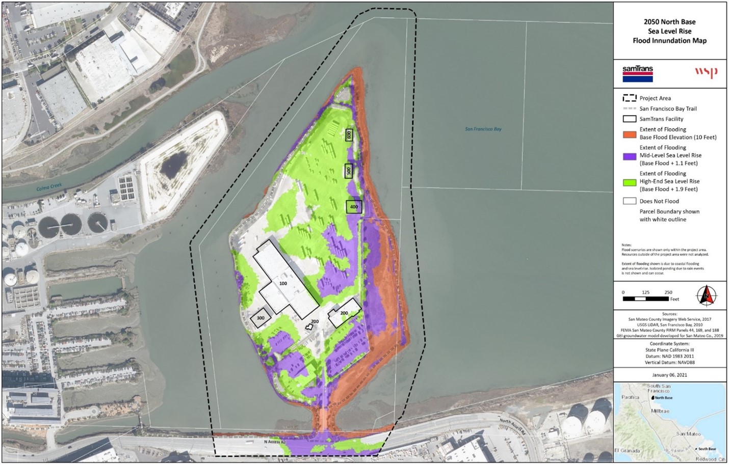
San Mateo County is extremely vulnerable to sea level rise (SLR) and flood inundation due to densely populated, low-elevation areas. The Bay Area is also particularly vulnerable to high heat because it has historically not experienced or prepared for extreme temperatures. Low-income public transit riders, who are a key demographic of SamTrans’ ridership, are the most likely to suffer harm from climate impacts such as SLR and high heat.
The SLR vulnerability analysis used available data to evaluate four climate change-related  hazards: SLR, storm surge, fluvial flooding, and land subsidence. The high heat vulnerability analysis used countywide data to evaluate the number of days per year projected to exceed 100°F and developed a heat sensitivity index for SamTrans based on select indicators from the California Heat Assessment Tool (CHAT).
Funding Source
The Project received $193,102.00 from Caltrans through its State Climate Adaptation  Planning Grant Program. This amount was supplemented by $25,018.00 in local matching funds.
Research and Data
In both the SLR analysis and the heat analysis, the Plan built on studies prepared by other regional governments:
- San Francisco International Airport. 2015. San Bruno Creek/Colma Creek Resiliency Study Final Report. https://seachangesmc.org/wp-content/uploads/2015/08/SanBruno_Colma-Resiliency-FINAL_Rpt_150820.pdf
- San Mateo County. 2018. San Mateo County SLR Vulnerability Assessment.
 https://seachangesmc.org/
 - San Mateo County. 2019. Climate Hazard Vulnerability: Flooding and Erosion.
- San Mateo County. 2018. Climate Ready San Mateo County Future Heat Risks PPT.
- California Heat Assessment Tool (CHAT)
Challenges
Climate change modeling remains complex and requires making informed assumptions to model uncertain future outcomes under variable conditions.
Outcomes
The SLR analysis found that both of SamTrans’ bus facilities are vulnerable to SLR in the 2050 and 2100 timeframes. The Plan demonstrated that regional coordination would be critical to addressing these vulnerabilities as neither site can be protected in isolation. A lifecycle benefit-cost analysis indicated that the construction of a levee around the perimeter of North Base, totaling 19 feet at the crest, would save SamTrans significant long-term costs. Addressing flood risk effectively at South Base necessitates regional coordination; SamTrans neither owns nor has jurisdiction over the infrastructure that will require modification to provide flood protection.
The high heat analysis found that while SamTrans facilities and assets do not face significant near-term heat risk, passengers are likely to experience escalating heat impacts as the century progresses. Approximately 67% of SamTrans riders have no access to a car, and nearly 60% of riders have an annual household income of less than $50,000. SamTrans’ bus, paratransit and shuttle services provides over 43,000 daily passenger trips. The primary recommendation from the high heat impact analysis is for SamTrans to install shelters or other shade features in locations that are vulnerable to high heat and to improve its bus shelter by adding shade structures, benches, and other amenities that will reduce heat risk to passengers waiting for service.
Replicability
The vulnerability analyses are replicable and were built on previously completed regional vulnerability studies. The vetting of resilience solutions followed the Naval Facilities Engineering Command (NAVFAC) Climate Change Planning Handbook framework. SamTrans employed a standard benefit-cost analysis to evaluate the levee alternative at North Base, which is consistent with best practices.
Additional Resources
- San Mateo County SLR Vulnerability Assessment Final Report
- Bay Conservation and Development Commission Adapting to Rising Tides Bay Area
- Naval Facilities Engineering Command (NAVFAC). 2017. Climate Change Planning Handbook: Installation Adaptation and Resilience. https://www.louisberger.com/sites/default/files/NAVFAC-Climate-Change-Handbook-Jan2017.pdf. (As of December 13, 2019)
- Shirzaei, M. and Büurgmann, R. 2018. Global Climate Change and Local Land Subsidence Exacerbate Inundation Risk to the San Francisco Bay Area. https://advances.sciencemag.org/content/4/3/eaap9234. (As of June 21, 2019)
- California Ocean Protection Council. 2018. State of California Sea-Level Rise Guidance. 2018 Update. http://www.opc.ca.gov/webmaster/ftp/pdf/agenda_items/20180314/Item3_Exhibit-A_OPC_SLR_Guidance-rd3.pdf
- California Ocean Protection Council. 2020. Strategic Plan to Protect California’s Coast and Ocean 2020 – 2025. https://www.opc.ca.gov/webmaster/ftp/pdf/2020-2025-strategic-plan/OPC-2020-2025-Strategic-Plan-FINAL-20200228.pdf. (As of December 16, 2020)
- Cal-Adapt. Extreme Heat Days and Warm Nights. https://cal-adapt.org/tools/extreme-heat/. (As of December 13, 2019)
- California Department of Public Health. 2017. Climate Change and Health Profile Report San Mateo County. https://www.cdph.ca.gov/Programs/OHE/CDPH%20Document%20Library/CHPRs/CHPR081SanMateo_County2-23-17.pdf. (as of December 13, 2019)