Highway 37 Climate Adaptation
SB1 Adaptation Planning Grant: Final Case Study
Brief Summary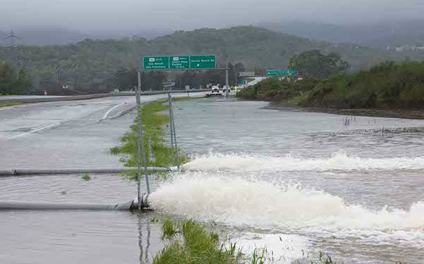
Highway 37, an essential people- and goods-movement corridor in Marin County, is currently subjected to storm runoff and tidal flooding and will be further impacted by projected sea level rise. Building on multiple recent studies, including the Metropolitan Transportation Commission (MTC) preliminary corridor analysis, this project distilled the information from those studies and developed four approaches for consideration in developing an action plan. The approaches and respective design concepts vary in time horizon, scope, and cost, taking into account ongoing and projected flooding issues from increased storm flows and sea level rise in the east-west transportation corridor through the Novato Baylands, reducing the potential disruption to and/or closure of transportation facilities and mitigating impacts in the area from such flooding using (adaptation) best practices for stormwater and tidal flooding management.
The study and its recommendations were a collaborative effort, including the County, Transportation Authority of Marin (TAM), Caltrans, water and sanitary districts, regional and state agencies involved in flooding, sea level rise, and water quality issues, land management agencies, community organizations, and the public at large. The strategies developed through the study serve as a framework for policy language to incorporate into related planning and guidance documents, such as local General Plans, Community Plans, Specific Plans, and transportation planning documents overseen by Caltrans, MTC, TAM, and other relevant agencies, including upcoming project development studies being undertaken by Caltrans and MTC. Overall, the study provides a specific group of vetted and viable project approaches that are ready to seek funding for design and construction.
The study aligns with several stated goals and State policies by looking at the transportation and flooding concerns in the Highway 37 corridor comprehensively, and seeking to develop solutions that address the impacts of storm-related and tidal flooding which are realistic, cost-effective, environmentally sound, and durable. Additionally, Caltrans’ Highway 37 Transportation Concept Report and the state’s Regional Transportation Plan both call out the need to address the transportation and flooding issues in this corridor.
Lead Agency and Partnerships
Marin County Department of Public Works, which also includes Flood Control District staff, was the lead agency in partnership with TAM, responsible for completion of the grant. Additional partners in executing the work included affected agencies such as Caltrans, MTC, the City of Novato, Novato Sanitary District, and Sonoma Marin Area Rail Transit. Additional coordination took place with other related groups and agencies, such as state and federal water and resource agencies, community groups, and other interested parties.
Drivers
There have been concerns for many years, especially after a month-long closure in winter 2017 and further long-term closures in winter 2019, about the viability of Highway 37, given its low elevation and high stormwater flows and increasing tidal levels. Recent studies of the entire highway, between Novato and Vallejo, by the Metropolitan Transportation Commission have identified the key areas of concern for the viability of the corridor and developed concept solutions for further analysis.
Engagement Process
The highway is a primary route for workers commuting between their homes and places of employment, connecting Marin County with Vallejo and Solano Counties to the east, and Sonoma and Napa Counties to the north. The extremely high housing costs in the Bay Area force many workers to live far from their jobs, such as service and retail workers who commute into Marin, agricultural and tourism-support workers who commute northward, and other low-wage workers who work throughout the North Bay. Highway 37 is a lifeline to those workers who may reside in one of several disadvantaged communities around the North Bay region or beyond and face limited mobility opportunities. The closure of Highway 37 from flooding creates untenable circumstances in their ability to get to their place of employment.
Community engagement built upon already-established efforts, such as through interagency and community interest groups were involved in recent study efforts related to sea level rise and stormwater flooding in the area. As the area surrounding the highway is uninhabited, outreach efforts were more focused on roadway user groups and those regionally affected by the operation of the highway, particularly those who are dependent on the highway to commute to their place of employment. Previous outreach efforts compiled extensive data on commuting patterns and transit viability in the corridor which was incorporated into the initial development of potential design approaches.
The project conducted a multi-faceted community outreach approach throughout the process to inform and educate the community on issues in the corridor. It solicited concerns and input on areas of interest, such as from adjacent landowners and from the sub-regional corridor working group; and provided and discussed a range of alternative solutions seeking input on preferred approaches, preferred solutions, and strategies which evolved into the four design approaches.
Climate Impact Areas
Given its base elevation, projected sea level rise will further impact the roadway. Due to the lack of suitable alternative routes, closure of the roadway due to flooding diverts traffic to other routes not designed for current and projected volumes of traffic, particularly movement of freight between the North Bay and North Coast. In addition to a low base elevation, the corridor is affected by structures and bridges that impede water flow in the Novato Creek drainage out to San Pablo Bay, causing backups and pooling that floods the roadway. The increased intensity of storm flows down the constrained creek, combined with tidal action, sedimentation, and increasing sea levels are resulting in more frequent flooding situations that inundate the highway and render it impassible. Potential alternative treatments to raise the roadway or to improve upon the current system of levees, or a combination thereof, were analyzed.
Funding Sources
The project was funded through SB 1 Adaptation Planning grant funds ($130,170), the Transportation Authority of Marin ($8,915), and the Marin County Flood Control District #1 ($8,915).
Research and Data
The study collected and distilled existing data and studies (link below under Additional Resources) relevant to the corridor and identified information gaps needing additional analysis, and identified and analyzed vulnerabilities in the corridor and what the implications are for various approaches and also if no additional actions are taken. The plan incorporates both previous studies and ongoing flooding and sea level rise efforts in the Novato Creek watershed with targeted analysis and modeling of the Highway 37 transportation corridor in developing viable, deliverable solutions, with pros and cons of each along with construction and long-term costs of each identified.
Challenges
Budget constraints limited the depth of analysis, but using other studies and data collected to date have provided baseline information from which more focused modeling efforts can be made. Recognizing the multiple landowners on either side of the highway whose participation in a solution that would benefit not only the highway but also adjacent vulnerable assets was and will continue to be an ongoing challenge to arrive at a preferred solution, though by being more inclusive and expansive in scope, multiple benefits could be derived.
Outcomes
The County of Marin and Transportation Authority of Marin (TAM) have provided a range of potential but viable improvements to the Highway 37 corridor in Marin County (Highway 101 to the Petaluma River) to address both ongoing and projected flooding and sea level rise which affect the transportation facilities in the corridor and surrounding lands. Outcomes include:
· Long- and short-term strategies to reduce the potential for repeated traffic diversion impacts that have resulted and could result from closure of the transportation facilities from storm-related creek flows and tidal surges, and projected sea level rise.
· Analysis of hydraulic and hydrologic modeling of the effects of various proposed solutions on seasonal and tidal flooding and sea level rise and identification of potential benefits of habitat and wetland restoration in the area as part of a more comprehensive highway project.
· Development and analysis of potential engineering solutions to the transportation corridor and related flood/baylands management facilities, their projected impacts, and estimated costs.
· Development of viable conceptual designs that address identified concerns and vulnerabilities to the Highway 37 corridor and its essential role in the region’s transportation network through analysis and modeling of proposed approaches under various future scenarios.
· Identifying potential funding sources for preferred solutions in the corridor and develop a funding plan that enables projects to compete for available funding for design and construction.
Replicability
From an environmental and design perspective, the findings of the Highway 37 study would be germane to other similarly-situated highways, in particular those affected by both tidal flooding and storm surge impacts and which are currently subject to the performance of infrastructure such as levees and pumps which are not under the control of Caltrans. However, while the roadway is a critical link for commerce and commuting with no reasonable alternative routes, it does not have any development adjacent or proximate to it so impacts to adjacent development was not part of this study’s analysis, beyond potential environmental benefits from restoration of previous baylands through which the highway traverses.
Additional Resources
The Study website contains the final study as well as resource documents and previous studies used in its preparation.
Further Information:
Dan Dawson, Marin County Department of Public Works 415-473-6287 / ddawson@marincounty.org
Joanna Dixon, Marin County Department of Public Works 415-473-7031 / jdixon@marincounty.org