Los Angeles County - Integrated Wildfire Safety Plan
Proposition 84 Wildfire and Resilience Planning Grant Case Study
Brief Summary 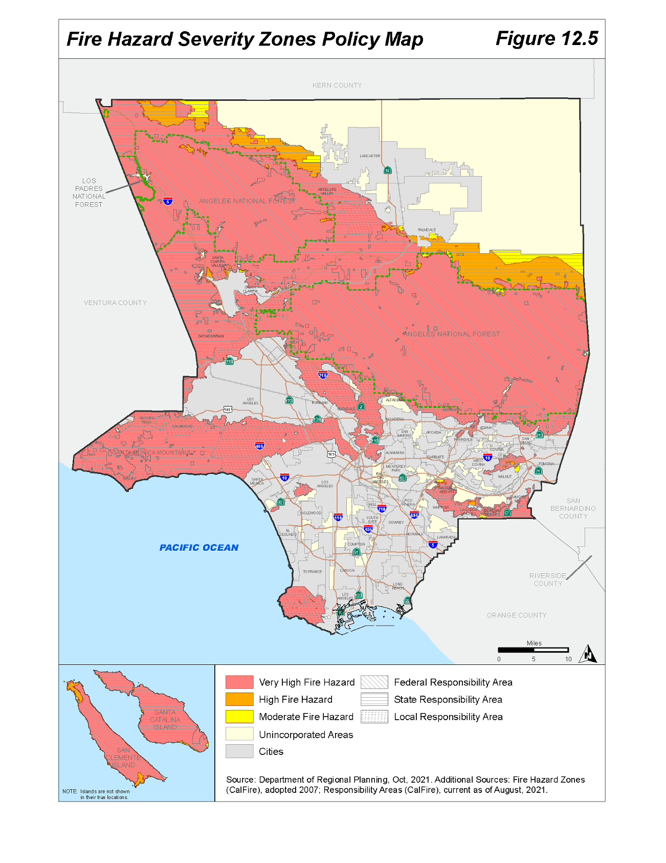
Los Angeles County ideveloped an Integrated Wildfire Safety Program (IWSP), a comprehensive approach to tackle the early phases of wildfire risk reduction by aligning land use policies that limit increased exposure with developing collaborative fuels management tools. The IWSP consists of the update to the General Plan Safety Element and development of a Wildfire Risk Assessment (WRA), Unified Land Use Plan (ULMP), and Countywide Community Wildfire Protection Plan (CCWPP). The ISWP will establish a common wildfire planning framework for all unincorporated communities vulnerable to wildfire and facilitate the implementation of wildfire resilience and recovery strategies. The project is the first comprehensive wildfire prevention planning approach for the entirety of the unincorporated Los Angeles County.
The IWSP’s objectives are to: 1) help communities develop pre-disaster wildfire preparedness and recovery plans; 2) unify and focus efforts to mitigate risks for existing communities, and 3) inform policy and standards for development within the Fire Hazard Severity Zones (FHSZ).
As part of the IWSP, the ULMP will identify appropriate fuels reduction programs and green infrastructure approaches to reduce wildfire intensity, while protecting the region’s unique biodiversity. In addition, the CCWPP will help Los Angeles County deliver a broad, consistent approach to wildfire resiliency planning to a large number of unique communities with severe wildfire risks. This countywide wildfire planning will benefit the broader community by ensuring that local wildfire mitigation projects are regionally complementary, to help reduce local fire risk as well as major regional conflagrations. By providing a foundation for mitigation and resilience planning, the CCWPP will help build the planning and implementation capacity of vulnerable communities countywide.
The project commenced in October 2021, and concluded in October 2022. The year-long project delivered the WRA and ULMP along with the first complete draft of the CCWPP. Subsequent drafts or projects stemming from the CCWPP will be conducted through separate project phases.
Lead Agency and Partnerships
Los Angeles County Department of Regional Planning (DRP) worked in close partnership with the Los Angeles County Fire Department (Fire). Members from Los Angeles County Public Works, National Park Service, CalFire, California State Parks, and Forest Service also served in technical advisory roles. Also involved in the process were the unincorporated fire safe councils including, but not limited to, the North Topanga Fire Safe Council and Crescenta Valley Fire Safe Council.
Drivers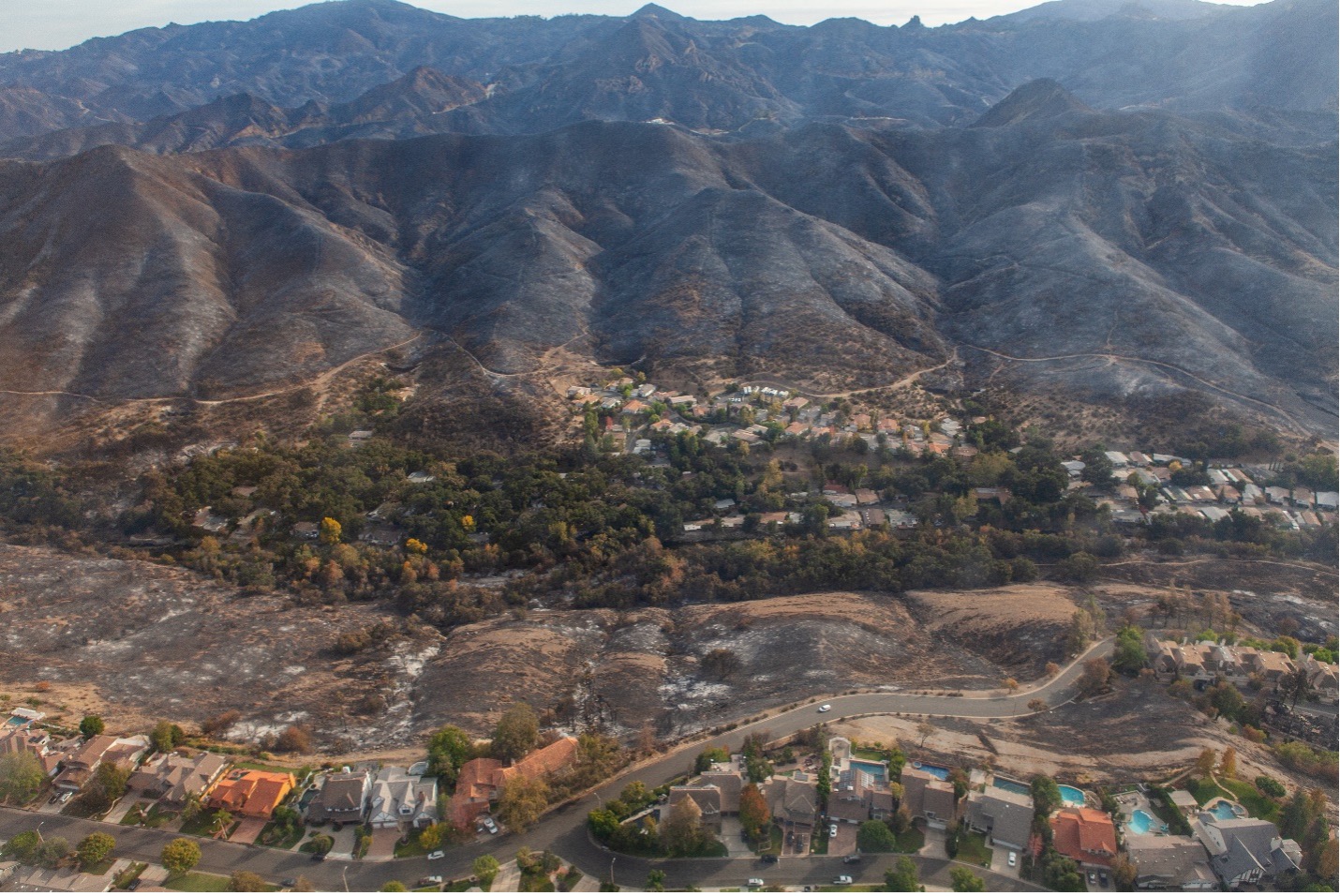
The Woolsey Fire in 2018 and Tick Fire in 2019 together burned more than 96,000 acres in highly populated Los Angeles County, requiring the evacuation of over 250,000 residents. The Woolsey Fire destroyed 1,643 structures and caused 3 casualties. In the aftermath, Governor Newsom emphasized the need for jurisdictions to update codes, harden homes, strengthen evacuation, and improve land use decisions to reduce loss of life and property from wildfires.
Los Angeles County needs to strengthen county-wide policies to mitigate wildfire risks and increase resiliency in existing communities, considering the experienced climate change intensification. Recent wildfires have established the critical need for pre-disaster risk reduction and hazard mitigation planning to reduce wildfire risk and facilitate post-disaster recovery. Furthermore, land use policy prior to the project had not been used to limit development in high-risk areas, which required amendment to deprioritize new development in high fire hazard risk areas.
Engagement Process
The IWSP utilized several different engagement strategies, including informal and formal virtual meetings, virtual trainings, in-person presentations and meetings, public information booths at public events, online surveys, and public mapping tools to provide as well as obtain information from communities county-wide. DRP conducted targeted outreach to communities within high fire hazard areas, particularly those with socially vulnerable populations, to understand their attitudes, perceptions of risk, knowledge of wildfire regulations, and perceived barriers to reducing wildfire risk. To expand the engagement efforts, DRP utilized these findings to coordinate with Fire Safe Councils to institute an education series on how to reduce wildfire risk.
Climate Impact Area
The IWSP sets a county-wide framework for fire risk and land management priorities, which improves the County’s ability to plan for and implement long-term goals like greenhouse gas emissions reductions and reducing climate and hazard vulnerability.
The County’s Climate Action Plan was developed concurrently and considers the heightened wildfire risks due to GHG emissions and climate change, and cascading climate impacts. In addition, the LA County Climate Vulnerability Assessment provides additional information on social and physical vulnerability to climate impacts, including wildfire, within the county. Data that was generated for the physical vulnerability analysis was incorporated into the IWSP’s Wildfire Risk Assessment model.
Funding Source
The project received $175,315 in Proposition 84 grant funding and $73,795 in local funding, for a total project cost of $249,110.
Research and Data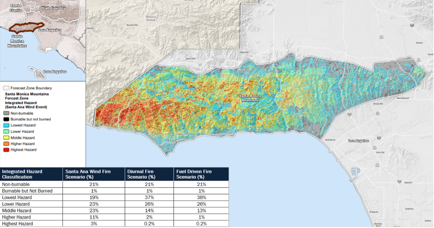
The IWSP utilized several data sources and platforms. GIS data was provided by Fire, the Chief Executive Office and Office of Sustainability, as well as the LA County in-house Regional Planning GIS team. IFTDSS and FlamMap software was utilized using LANDFIRE data to model fire behavior and determine areas of highest risk. The project also deployed an online Fire Risk Mapper for public use, in which residents are able to report fuels and fire hazards through location mapping, hazard description, and photo submissions. Regional Planning and Fire are able to utilize the public feedback to ground truth reports and incorporate them into fire mitigation efforts.
Challenges
Planning for a diverse and large land mass area with numerous communities with varying engagement levels poses extensive coordination challenges. Although consistent, significant fire risks occur throughout the county, there are several distinctive weather forecast zones, geographic typologies, fuel types, and fire regimes that make consistent fire planning difficult. Furthermore, planning at this scale requires establishing shared goals across dozens of communities and jurisdictions that have their own planning objectives and climate risks.
It was critical to partner with Fire and have a consistent team of fire chiefs and foresters on the project. Fire played an outsized role in integrating the IWSP goals, strategies, and data with existing fire operations. Their expertise and insight guided the IWSP development process.
Outcomes
The IWSP is the first complete draft of the Los Angeles Countywide Community Wildfire Protection Plan, and includes:
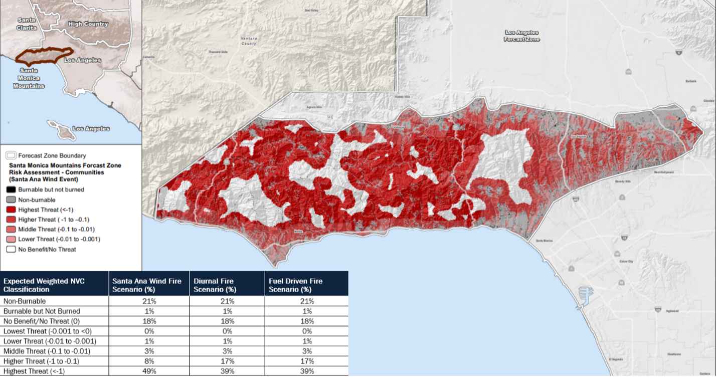
- Wildfire Risk Assessment – The WRA provides a model hazards and wildfire threats to high value resources and assets. The WRA generates multiple fire regime models for each of the five forecast zones within Los Angeles County, to identify areas of highest risk based on fire behavior scenarios.
- Unified Land Management Plan – The ULMP identifies vegetation management techniques, fuel treatment types, and implementation methods for the county’s various regions. Recommendations include management action to minimize fire risk and best management practices for sensitive resources.
- Countywide Community Wildfire Protection Plan – The CCWPP provides a comprehensive action plan for high priority management areas and techniques for fire risk reduction project implementation.
Replicability
Los Angeles County’s IWSP offers lessons for regional efforts for developing a coherent wildfire resilience strategy. Other communities can replicate the project’s team composition, particularly the partnership with the local fire department and integration of multiple agency and stakeholder groups. In addition, communities can replicate a similar community engagement strategy, which utilizes a variety of outreach methods to boost participation, interaction, and information gathering. The project results will be applicable for communities that are tasked with addressing increasing wildfire risks and climate threats to vulnerable populations across a diversity of landscapes and communities.
Additional Resources
Los Angeles Countywide Community Wildfire Protection Plan – Project website: https://planning.lacounty.gov/site/climate/ccwpp/
Los Angeles County Climate Vulnerability Assessment: https://ceo.lacounty.gov/wp-content/uploads/2021/10/LA-County-Climate-Vulnerability-Assessment-1.pdf
Further Information
Thuy Hua, Supervising Regional Planner: thua@planning.lacounty.gov
Iris Chi, Regional Planner: ichi@planning.lacounty.gov
Cameron Robertson, Regional Planner: crobertson@planning.lacounty.gov